Perth is in store for a scorching Christmas Day as an extremely hot air mass heads towards southwestern Australia.
Earlier this week, temperatures reached 47.9ºC at Mardie in WA’s Pilbara district. This was the highest temperature recorded in Australia and the Southern Hemisphere so far this year.
Now, this heat is spreading further south as a low pressure trough draws inland heat towards the state’s lower western coastline.
Perth is forecast to reach the mid-thirties by Thursday, high-thirties on Friday and into the forties from Saturday until at least Monday.


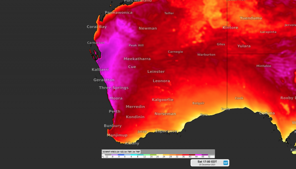
Images: Modelled surface air temperature on Friday, Saturday (Christmas Day), Sunday and Monday.
At this stage, the city could hit 42ºC on Saturday, which would be the hottest Christmas day since 1968. If it exceeds 42.0ºC, it will be the city’s hottest Christmas Day on record.
If all three days from December 25 to 27 exceed 40ºC, this will also be Perth’s hottest trio of days on record starting on Christmas Day.
Looking further ahead, temperatures will drop a bit from Tuesday as sea breezes become more prominent. However, daytime maximums should still reach the low-to-mid thirties each day from Tuesday, December 28 until New Year’s Eve.
There is a good chance that Perth will reach at least 32ºC every day between Christmas Eve and New Year’s Eve, which hasn’t happened in eight years.
During this holiday heatwave, night time temperatures will also be oppressive. Minimum temperatures are only expected to reach 25ºC on Christmas night and Boxing Day night. This will have air conditioners running through the night to help locals sleep off their big lunches.
There are indications that temperatures may drop a bit in the first few days of the new year, however, there are no signs of a strong cool change in the coming fortnight. Weatherzone forecasts extreme heat and 14 day temperature forecasting, for more information, please contact us at business@weatherzone.com.au.