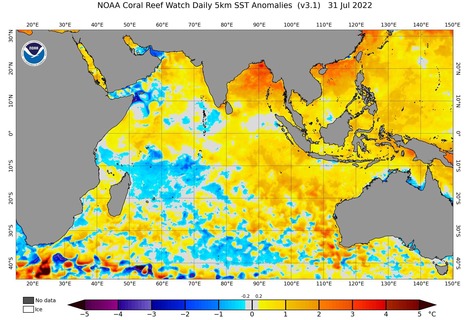
A wet spring could be on the cards for large parts of Australia with a negative Indian Ocean Dipole now officially underway in the Indian Ocean.
A negative Indian Ocean Dipole (IOD) refers to a pattern of sea surface temperatures in the tropical Indian Ocean that causes more moisture-laden air to flow towards Australia.
These negative IOD events, which occur on average once every five years, typically enhance northwest cloudbands over Australia and produce above-average rain over large areas of the country’s south and southeast during winter and spring.
The Bureau of Meteorology has today declared that a negative IOD event is underway to the northwest of Australia. This declaration comes after sea surface temperatures in the Indian Ocean have remained near or exceeded the negative IOD threshold for the last eight weeks.
This is now the 2nd consecutive year to be declared a negative IOD year, following a relatively weak event in 2021. This is the first time we have seen two consecutive negative IOD years since reliable records of the IOD began in 1960.
Unlike last year’s event, this year’s negative IOD is expected to be strong and last through the remainder of winter and spring.
What does this mean for Australia’s weather?
A negative IOD can have a big impact on Australia’s weather during winter and spring.
The pattern of sea surface temperatures during negative IOD events typically cause more atmospheric moisture to flow over Australia from the northwest.
This moisture can fuel vast northwest cloudbands, which can cause widespread rain, thunderstorms and flooding. The map below shows how negative IOD events typically affect Australia’s winter-spring rainfall.
Image: This map shows the impact a negative IOD would typically have on Australia’s rainfall during winter and spring. Source: Bureau of Meteorology
As expected, the latest seasonal outlook for Australia predicts a high chance of above-average rainfall over most of Australia during the next three months.
Image: Rainfall outlook for the three-month period from August to October 2022. Source: Bureau of Meteorology.
The increased cloud cover caused by negative IOD episodes can also limit daytime heating over Australia. This often causes below-average daytime temperatures across large areas of the country. The blue areas on the map below are more likely to see cooler-than-average winter and spring days when the IOD is negative.
Image: This map shows the impact a negative IOD would typically have on Australia’s maximum temperatures during winter and spring. Source: Bureau of Meteorology
But while days are often colder for some areas of Australia during a negative IOD, nights are usually near-average to warmer-than-average in winter and spring. This is because clouds act like a blanket at night and helps trap some of the previous day’s warmth near the ground.
Image: This map shows the impact a negative IOD would typically have on Australia’s minimum temperatures during winter and spring. Source: Bureau of Meteorology
In general, extremely cold days are more likely across southeastern Australia during a negative IOD, while extreme cold nights are less likely.
The IOD can also influences the quality and quantity of snow in southeastern Australia. The combination of more rain and lower daytime temperatures during a negative IOD typically means better snow conditions in the mainland Alps. For more information on Weatherzone’s seasonal forecasts, please contact us at business@weatherzone.com.au.


