Bankstown has experienced its equal coldest day in 38 years today, with the maximum temperature unable to break above 10 degrees. Sydney’s maximum temperature also struggled, with the capital shivering through the coolest day in 37 years.
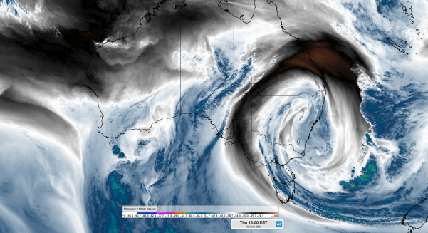
A freezing air mass has wrapped around a cut-off low and into NSW, bringing icy temperatures and spreading low level snow across NSW. In fact, the ski resorts in the Snowy Mountains have seen over 60 centimetres of snow since Tuesday, due to moisture-laden air and the freezing temperatures.
Sydney and Canberra were officially the coolest capital cities in Australia this afternoon. As of 3pm AEST today, Melbourne was four degrees warmer than Sydney, which is not unheard of, but unusual.
Typical low-pressure systems and cold fronts, drag cold air across Victoria and into NSW, due to cool southerly winds. So why is Melbourne warmer?
There are two contrasting air masses wrapping around the cut-off low. The warm airmass moved into Victoria today, creating these mild temperatures (for Melbourne) and ensuring the Victorian alps missed out on the significant snowfall.
At the same time a very frigid airmass has wrapped its way into NSW, creating some of the coolest temperatures we have seen in years. The ski resorts in the Snowy Mountains have seen over 60 centimetres of snow since Tuesday, quite a contrast to the Victoria ski fields.
Queenslanders have also donned their jackets for the first time in a while. Brisbane’s minimum temperature last night dropped to a very cool seven degrees, with the maximum temperature today struggling to reach 19 degrees.
While the remainder of the states are set to warm up from tomorrow, Queensland will see one more day of below normal temperatures.
The cut-off low has also brought significant cloud cover to Victoria and NSW, with solar input way down today, as well as the temperatures.
For 14-day temperature forecasting and more, please contact us at business@weatherzone.com.au.


