A clear La Niña signal is starting to emerge in the central Pacific Ocean, however the declaration of La Niña depends on a few factors that are still a coin flip chance of occurring.
What is La Niña?
La Niña is the cool phase of the El Niño Southern Oscillation (ENSO) that occurs when cooler than normal waters push westward along the equatorial Pacific Ocean. This ocean pattern, coupled with changes to the overlying atmosphere, cause warmer waters and more rising air to occur over northern Australia, typically increasing spring and early summer rainfall.
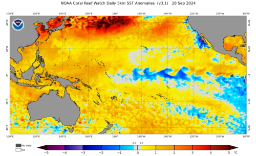
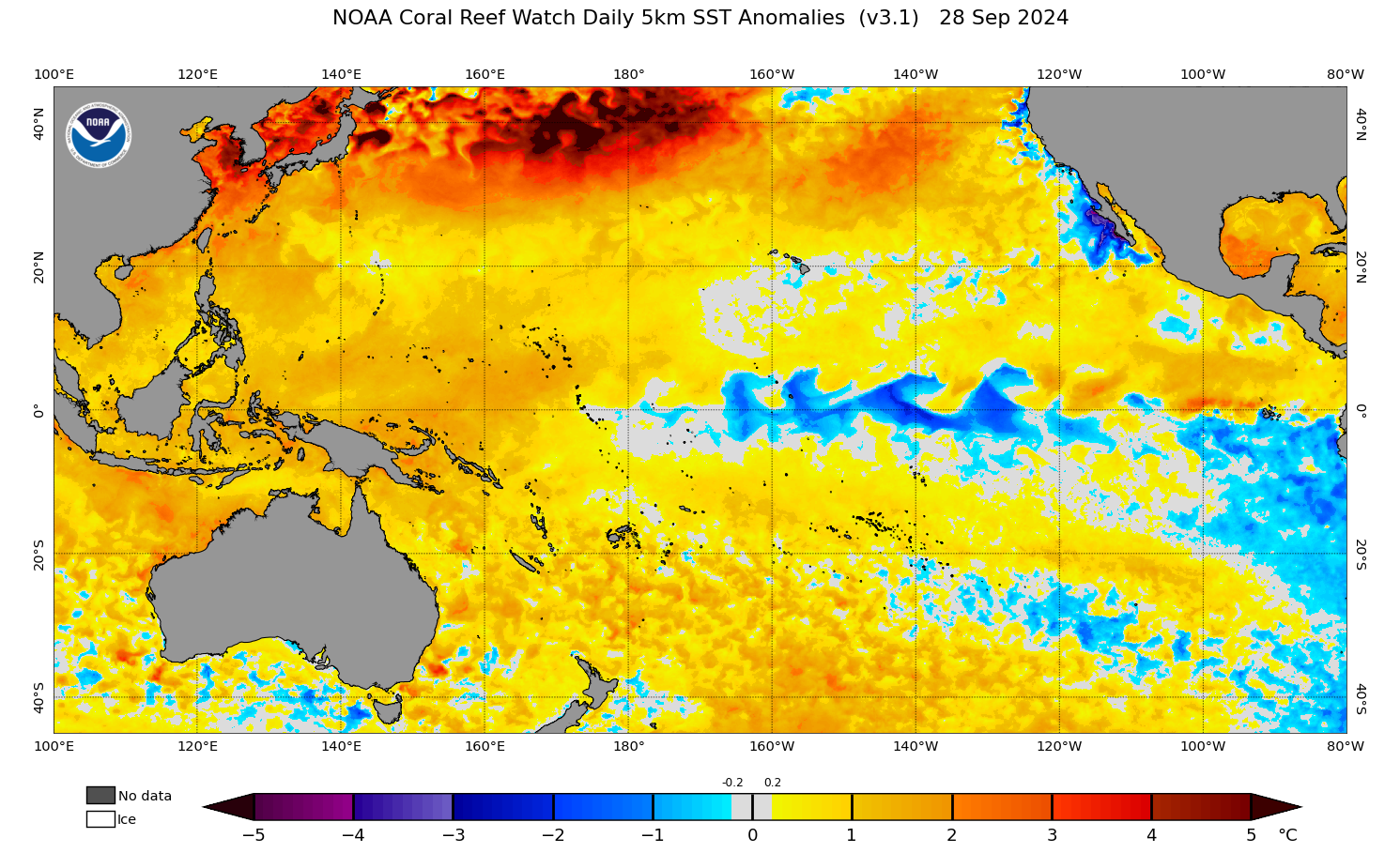
Image: Sea Surface Temperature anomalies from NOAA Coral Reef Watch over the last 30 days, showing a cool tongue of water moving into the central Pacific, a sign that a La Niña is becoming more likely to develop this year.
Current ENSO Rating
The Bureau of Meteorology has had a La Niña Watch in place since May. This rating means there is a 50% chance of a La Niña developing this year, or about twice the normal likelihood.
The next step of the declaration process from the BoM would be a La Niña Alert. This rating means there is a 70% chance of a La Niña developing this year. To meet this rating, any three of the following four criteria must be met; two for the oceans and two for the atmosphere:
- Sea surface temperature: A clear cooling trend has been observed in the Nino-3 or Nino-3.4 regions of the Pacific Ocean during the past three to six months.
- Models: A majority of surveyed climate models show sustained cooling to at least 0.8 °C below average in the Nino-3 or Nino-3.4 regions of the Pacific Ocean by the late winter or spring.
- Winds: Trade winds have been stronger than average in the western or central equatorial Pacific Ocean during any two of the last three months.
- Southern Oscillation Index (SOI): The two-month average Southern Oscillation Index is +7 or higher.
Atmospheric Conditions
Of these four criteria, the only one that is clearly satisfied is the third. Trade winds along the equatorial Pacific have been above average consistently since July. This is enough to satisfy not only the La Niña Alert definition, but also the full La Niña definition.
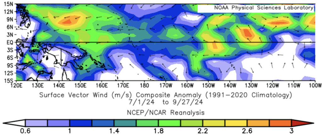
Image: Surface wind anomalies from July to September 2024 from NCEP/NCAR Reanalysis. The easterly trade winds have been consistently stronger than average over the equatorial Pacific, shown in the blue and green shading, and the black arrows.
Despite the strong atmospheric signal from the trade winds, the SOI has not shown any sustained deviation from zero over the past three months, and it is not expected to reach the official definition for La Niña this year.
Ocean Conditions
While there has been a clear cooling trend in the Nino-3.4 region in recent weeks, there has been considerable fluctuations so far this year. Since April, when the 2023-24 El Niño was declared finished, Nino-3.4 ocean temperature anomalies have been hovering slightly above zero, with a nose-dive only occurring in the last 4 weeks. However, this behaviour is quite similar to the La Niña event in 2021, so it is certainly possible that La Niña still develops from here.
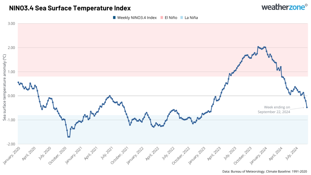
Image: Nino-3.4 Sea Surface Temperature weekly index readings.
Finally, three of the seven international models are forecasting the Nino-3.4 to fall below the BoM’s La Niña threshold of –0.8°C, with another just reaching –0.8°C. This technically makes it a “majority of surveyed climate models”, although the continuity of this cool water is debatable.
Sub-Surface Ocean Conditions
Something that has been on the minds of forecasters for months now, is the abundance of cooler-than-average waters below the surface in the equatorial Pacific Ocean. This is often the first signal that a La Niña could develop in a given year, and this year has been no exception.
For nearly the entire year, a pool of very cool water has been sitting about 150m below the surface in the middle of the Pacific Ocean. A tongue of this cold water also extends east to near South America, where it is much closer to the surface, but has not fully reached the surface. Usually, this cold water would have triggered a La Niña by now, but temperamental weather in the region has continually disrupted this final step from occurring so far.
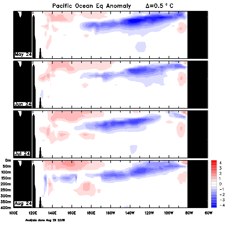
Image: Sub-surface ocean temperature anomalies showing the cold water in the equatorial Pacific sitting in a La Niña-like position for the last four months.
The US criteria for La Niña are easier to meet compared to the BoMs criteria. The US definition requires the Nino-3 or Nino-3.4 temperature anomaly to be below –0.5°C, with an expectation that those conditions will continue over the coming months. This makes it more likely that the US’ National Oceanic and Atmospheric Administration (NOAA) will declare a La Niña event this year.
Conclusion
Overall, the scales are evenly balanced for a La Niña to develop or not this year. What is looking likely is that if a La Niña develops in 2024, it is likely to be on the weaker side. Regardless of the declaration, climate forecasts for the next few months are still favouring for wetter than average conditions over northern and eastern Australia due to the warm waters surrounding Australia.
You have our insights to rely on to see you through complex situations, minimising potential loss of profit and maximising the safety of your staff and assets. For more information, please visit our website or email us at business@weatherzone.com.au.