
Weatherzone Business and Solcast are a market-leading partnership delivering highly specialised solar data to the Australian renewable energy industry.
Designed for utility scale solar sites, we offer you a globally proven solution.
With low upfront CAPEX and powerful cloud-based information systems, you can access a complete suite of irradiance and weather data to ensure forecast accuracy and improve site efficiency.
Solcast is the world leader in real-time actuals and rapid-update solar forecasts. This solution utilises Solcast’s centralised Amazon Web Services’ (AWS) cloud infrastructure for all complex algorithmic processes and data plumbing. You will gain the power of AWS to interpret and deliver your data at top speed, providing real-time, historical and forecasting estimates direct to your API.
Receive monitoring and support from the Weatherzone and Solcast teams, 24/7.

Utilising Solcast’s satellite fleet, sky-imagers and the SCADA data collected from your solar farm, you will acquire not only forecasting capability, but a precise picture of your actual yield and PR. Specifically built to ensure you meet the requirements of the AEMO and reduce your exposure to costly penalties.
Reap the efficiency and yield benefits of world-leading solar and irradiance data, without it costing the earth.
More than 60% of large-scale solar capacity in the NEM already relies on the data provided by the Weatherzone and Solcast solution.
Real-time error alerts are delivered when your SCADA system detect any drop in performance, so that a solution can be found quickly.

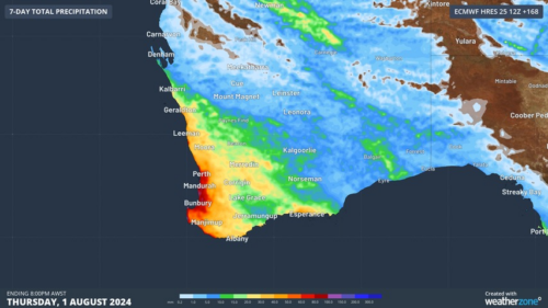
Another showery night in Perth has delivered enough rain to make this Perth’s first wetter-than-average month in more than one year. The animation below shows showers streaming over Perth and other areas of southwestern Australia late on Thursday. This wet weather was caused by persistent onshore winds along the west coast of WA, and the […]
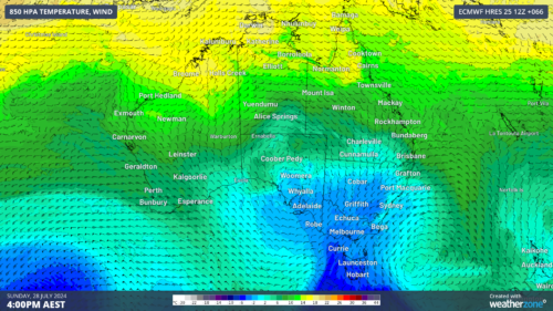
A frigid airmass originating from Antarctica is on its way to Australia on Friday, with the southeastern states expected to shiver through a prolonged cold spell. This airmass will arrive behind a cold front over the weekend and will linger over southeastern Aus well into next week. The satellite image below shows the cold front […]
The weather is feeling quite spring-like over northern NSW and southern Queensland, with warm days, smoke from hazard reduction burns and even a chance of thunderstorms on Thursday and Friday. Northerly winds ahead of a trough and cold front are creating a very mild winter’s day, with temperatures 4-7 degrees above the July average across […]
A wet spring could be on the cards for large parts of Australia, with several models suggesting a negative Indian Ocean Dipole could develop in the Indian Ocean. A negative Indian Ocean Dipole (IOD) refers to a pattern of sea surface temperatures in the tropical Indian Ocean that causes more moisture-laden air to flow towards […]
