
Weatherzone Business, a DTN company, has been providing weather intelligence and innovative forecasting systems to Australian businesses since 1998.
Every industry has unique needs when it comes to the complexities of weather risk and opportunity. We identify your business needs and deliver precision insights to optimise your efficiency and response.
We serve an array of industries and enterprises, each with their own individual relationship to the weather, and the risk and opportunities it creates. Choose from a wide offering of business weather solutions that cover everything from the safety of your teams and assets, to staffing, operations and maintenance planning. We are driven to give you full situational awareness of the weather and the capacity to make informed critical decisions, quickly.

Accredited and actionable weather intelligence – delivered direct to air and ground crew – supporting optimal safety and staffing.
Severe weather alerting, forecasting and EPA-approved blast dispersion modelling, custom-built for mine sites to mitigate risk.
Proven lightning alerting, power generation forecasting, severe weather, solar and wind data to support your operations and on-site safety.
Asset monitoring, solar actuals, PR and yield, power generation forecasts; lightning, flood, severe weather and fire alerting for peak safety and efficiency.
Real-time monitoring of severe weather and lightning alerting, with the ability to precisely anticipate disruptions and supply demand.
Power generation and weather forecasting with updates and granularity down to 5 minutes. Full risk overviews and long-term outlooks to support your predictions and profits.
Metocean services, data driven precision forecasting and alerting for offshore oil, gas or wind, shipping and port operators – keeping you, your team and assets safe.
Actionable weather intelligence and precise lightning alerting to enable the speed and accuracy of critical decision making in the field.
Engaging and reliable weather content to bring customers back to your media platform day after day.
Load More
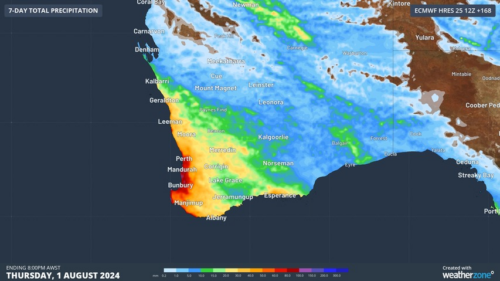
Another showery night in Perth has delivered enough rain to make this Perth’s first wetter-than-average month in more than one year. The animation below shows showers streaming over Perth and other areas of southwestern Australia late on Thursday. This wet weather was caused by persistent onshore winds along the west coast of WA, and the […]
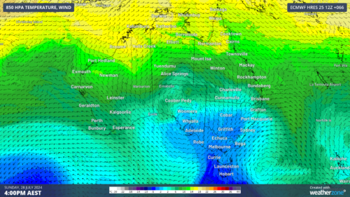
A frigid airmass originating from Antarctica is on its way to Australia on Friday, with the southeastern states expected to shiver through a prolonged cold spell. This airmass will arrive behind a cold front over the weekend and will linger over southeastern Aus well into next week. The satellite image below shows the cold front […]
The weather is feeling quite spring-like over northern NSW and southern Queensland, with warm days, smoke from hazard reduction burns and even a chance of thunderstorms on Thursday and Friday. Northerly winds ahead of a trough and cold front are creating a very mild winter’s day, with temperatures 4-7 degrees above the July average across […]
A wet spring could be on the cards for large parts of Australia, with several models suggesting a negative Indian Ocean Dipole could develop in the Indian Ocean. A negative Indian Ocean Dipole (IOD) refers to a pattern of sea surface temperatures in the tropical Indian Ocean that causes more moisture-laden air to flow towards […]
