
OpticastTM V5 is Weatherzone’s cloud-based, consensus forecasting solution that delivers precise weather data to your business, both nationally and globally.
Independently verified to significantly outperform other industry models, Opticast gives you a strategic advantage if weather impacts your enterprise. Armed with the most accurate nowcasting and forecasting data, you can mitigate operational and safety risks, and plan to make the most of severe weather windows.
Opticast is powered by machine learning, intelligently adapting to the local conditions of your site area. Gain a world-leading forecasting system that rapidly responds to changing conditions.
We give you the foresight to make quick and powerful decisions when you need to protect your valuable team and assets, and ensure maximum productivity.

Opticast utilises on-site observations to real-time verify, ensuring nowcasting accuracy.
Over 30 meteorological parameters, based on integrated global and regional Numerical Weather Prediction models, are delivered directly to your customisable interface.
Opticast provides you with clear and actionable insight to guide your business through increasingly extreme weather.
Regional and global NWP models integrate and optimise to your local environment.
Reliable 14 day forecasts allow you to plan key work schedules well in advance.
Severe weather and lightning alerts are delivered in real-time to any device, anywhere.

Weatherzone Business works tirelessly to provide the most accurate and comprehensive weather insights to serve your enterprise’s individual needs.
Whether you require severe weather warnings, rapid-update forecasting, solar actuals and forecasts, blast dispersion modelling, in-depth consultancy, easily deployed weather stations or any other high-precision meteorological service, we can create a reliable, bespoke solution.
The weather is our passion, as are the ways in which we can work with your business to manage the operational effects of the rapidly changing global climate.
Get in touch with us and we can equip you with the solutions you need to optimise your decision-making and mitigate serious weather risk and cost.
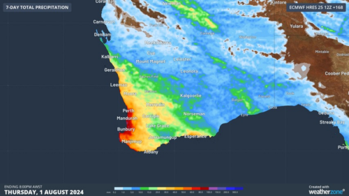
Another showery night in Perth has delivered enough rain to make this Perth’s first wetter-than-average month in more than one year. The animation below shows showers streaming over Perth and other areas of southwestern Australia late on Thursday. This wet weather was caused by persistent onshore winds along the west coast of WA, and the […]
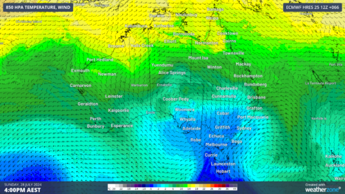
A frigid airmass originating from Antarctica is on its way to Australia on Friday, with the southeastern states expected to shiver through a prolonged cold spell. This airmass will arrive behind a cold front over the weekend and will linger over southeastern Aus well into next week. The satellite image below shows the cold front […]
The weather is feeling quite spring-like over northern NSW and southern Queensland, with warm days, smoke from hazard reduction burns and even a chance of thunderstorms on Thursday and Friday. Northerly winds ahead of a trough and cold front are creating a very mild winter’s day, with temperatures 4-7 degrees above the July average across […]

A wet spring could be on the cards for large parts of Australia, with several models suggesting a negative Indian Ocean Dipole could develop in the Indian Ocean. A negative Indian Ocean Dipole (IOD) refers to a pattern of sea surface temperatures in the tropical Indian Ocean that causes more moisture-laden air to flow towards […]
