
Weatherzone Business specialises in global aviation weather intelligence delivered in an easy-to-visualise format. Our solutions are developed in close consultation with the aviation industry to serve your in-flight requirements.
The WxBrief app is a decision support system customised to each flight, providing all required operational meteorological information in one place.
Pilots can request a flight pack by entering their flight number and the data is downloaded and processed typically within 30-40 seconds. The app updates in real-time during the flight where in-flight Wi-Fi is available, and Wi-Fi use within the cockpit is authorised.
Once a flight pack is downloaded it’s available throughout the entire flight, using the most recent meteorological data for the estimated position of the aircraft. The app requires no internet connectivity whilst in flight but can be updated if onboard Wi-Fi is available. Backup solutions (such as text only information) can be made available in the case of very poor connectivity.
No matter where you are, we’ve got you covered.

Equipped with complete visibility of impactful weather along your flight path, you can support your pilots’ response and your airline’s preparation for future risk. We provide you with clear and actionable insights to inform your operations, day and night.
Weatherzone Business’ experience and aviation weather services give your aircrew clear paths through complex situations, wherever they are in the world.
TAF/METAR information and timelines, forecasts, radar maps, one-minute observations, ATIS, runway wind calculator, route plans and more – everything your pilots need, easily accessed, in one place.
Weatherzone’s WxBrief aviation data adheres strictly to the regulations and standards of both the World Meteorological Organisation (WMO) and the International Civil Aviation Organisation (ICAO).
Wherever you are on your flight path, you have a projected view of your journey and destination to support your critical in-flight decisions. Comprehensive data guides you, protecting your aircrew and passengers.

Your trusted aviation weather data delivered through WxBrief app includes:
Route plan
Pilots can view the route plan with vertical profiles.
The winds shown are relative to aircraft track and heading, so it’s easy to understand the risk of head/tail or crosswinds. Jet streams can be seen, as well as key temperature levels for icing, relative humidity (cloud) and estimated topography.
Text view
Text view provides pilots with all other TAFs and METARs for ports not listed in the chosen flight plan. Selectable regions bring up a full list of TAF and METAR data as required so you have full visibility of emergency or alternate ports when required.
Chart view
Chart view offers maps layered with these parameters, enabling the ability to view future conditions along the flight path:
Feedback & support
Weatherzone operates a 24-hour, 365-day support desk to provide 2nd tier support on the app, with 1st tier supplied by your airline.
We take a consultative approach with industry customers to keep pushing the boundaries of science and technology. We keep you ahead of changing conditions, ensuring you can make informed decisions based on the most accurate and timely weather intelligence.
Rain, hail or shine: we are there for you to safeguard your flight crew and passengers.
Thunderstorms will develop over a broad area of NSW and Qld on Thursday afternoon, with severe storms likely in some areas. Thursday’s storms will be triggered by a low pressure trough interacting with an unstable atmosphere and moisture over eastern Australia. An upper-level trough above eastern Australia will also enhance wind shear in some areas, […]
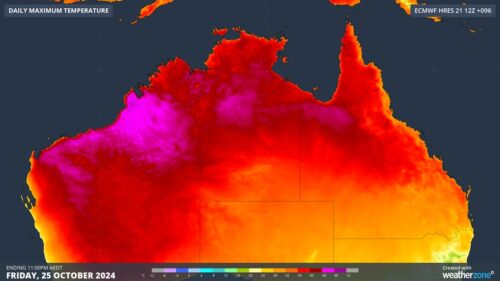
A burst of unusually hot weather will cause severe to extreme heatwave conditions across parts of three states and territories in northern Australia this week, with the heat also elevating fire danger ratings in some places. Northern Australia is certainly no stranger to heat at this time of year. The country’s highest temperature ever recorded […]

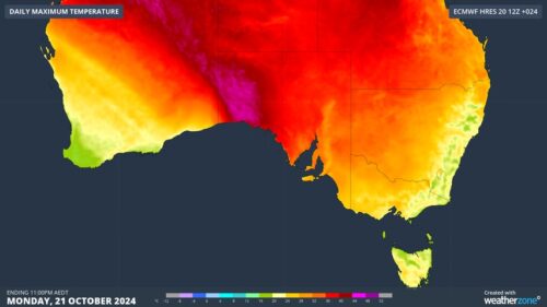
Melbourne is basking is spring-warmth today, ahead of a 10°C temperature drop tomorrow. The cities maximum is forecast to be 32°C on Tuesday afternoon, making it Melbourne’s warmest day in seven months and the first time the mercury has reached 30°C since March 18. Temps will also top 30°C across much of Victoria, with a […]
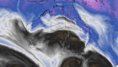
Parts of South Australia, Victoria and Tasmania will experience a burst of warm weather at the start of this week, briefly increasing fire danger ratings in some areas. The satellite images below show a cold front crossing southwestern Australia on Monday morning. Image: Visible satellite images showing clouds over Australia on Monday morning. This animation […]
