
Weatherzone Business delivers industry-leading weather and power generation forecasting and real-time alerting to inform your critical decision-making. Together we can keep your staff and assets safe, and efficiency high.
With lightning strikes, severe weather, flood and fire posing risk to wind farms across Australia, we have tailored solutions that can significantly improve your oversight and response.
Weatherzone’s Total Lightning Network comprises of regional and global sensors to detect intra-cloud (IC) and cloud-to-ground lightning (CG) strikes within your proximity thresholds. It provides unparalled detection accuracy (<200m) and real-time lightning alerts to any device across your operations team.
Your customizable Energyzone interface and Weatherguard app will provide access to the Total Lightning Network as well as centralized data from state and territory fire agencies, the Bureau of Meteorology, and over 30 national and international private and state organisations. This enables full situational awareness of weather conditions and fire risk, as well as severe weather alerting via text, email and phone call, so your staff can respond effectively when required.

Weatherzone’s Opticast Renewable Wind (RW) takes on-site observations and SCADA data, blending them with multiple NWP models to generate consensus forecast. Utilising an Artificial Neural Network (ANN) and statistical error estimation techniques, it vastly improves estimates of power generation and delivers precise hub height forecasting.
Meticulous forecasting to reduce your farm’s exposure to penalties.
Our Total Lightning Network is a globally proven solution to accurately alert your team to lightning strikes within defined thresholds, so they can respond quickly.
Opticast™ is our next generation nowcasting and forecasting solution trusted by the Australian Energy Market Operator, and businesses Australia wide. Precise weather intelligence to support safe and effective operations.
Gain power generation forecasts that utilise an advanced, multi-model approach. Based on your exact assets and location, it delivers a more precise estimation of power generation and hub height meteorology.

We thrive on challenge, next-generation science and customized service and are dedicated to helping you stay ahead of the curve.
Opticast™ RW provides 5-minute forecasting up to 72 hours and hourly forecasting out to 10 days forming a framework for your maintenance and operational planning. Customisable alerting covers lightning, severe weather, blade icing, high winds and humidity: all set within your specified thresholds.
Stormtracker, Weatherzone’s fully visualised Geographic Information System (GIS), plots ‘live’ lightning strikes, aged to 60 mins and mapped over your farm assets. This provides enhanced spatial awareness and understanding of the potential threat of storm activity to your operations and valuable assets.
Our proactive alerting systems can be configured to your requirements, aligning with local site needs, procedures and legislation. Avoid any unnecessary shutdowns that can occur due to imprecise forecasting of lightning and severe weather.
Your weather intelligence needs are as individual as your renewables business, and we collaborate with you to bring ease to your every day. Together we can improve safety and achieve optimal efficiency.
We are here for you: rain, hail or shine.
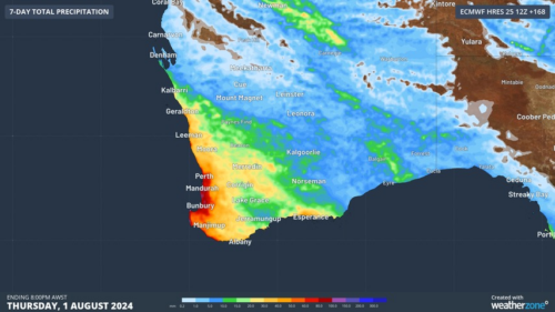
Another showery night in Perth has delivered enough rain to make this Perth’s first wetter-than-average month in more than one year. The animation below shows showers streaming over Perth and other areas of southwestern Australia late on Thursday. This wet weather was caused by persistent onshore winds along the west coast of WA, and the […]
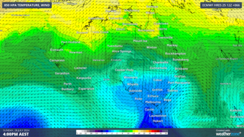
A frigid airmass originating from Antarctica is on its way to Australia on Friday, with the southeastern states expected to shiver through a prolonged cold spell. This airmass will arrive behind a cold front over the weekend and will linger over southeastern Aus well into next week. The satellite image below shows the cold front […]
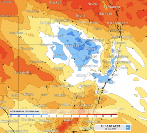
The weather is feeling quite spring-like over northern NSW and southern Queensland, with warm days, smoke from hazard reduction burns and even a chance of thunderstorms on Thursday and Friday. Northerly winds ahead of a trough and cold front are creating a very mild winter’s day, with temperatures 4-7 degrees above the July average across […]
A wet spring could be on the cards for large parts of Australia, with several models suggesting a negative Indian Ocean Dipole could develop in the Indian Ocean. A negative Indian Ocean Dipole (IOD) refers to a pattern of sea surface temperatures in the tropical Indian Ocean that causes more moisture-laden air to flow towards […]
