Embedded in Weatherzone Business’ industry interfaces, the system gives you a time advantage when monitoring conditions developing over your infrastructure and location.
Stormtracker is our Global Information System (GIS) tracking tool, providing multiple weather layers and zoom controls overlaid on a map of your location and infrastructure. You can choose a snapshot or full screen view, depending on your requirements. The maps allow you to monitor all weather, and specifically any systems likely to cause risk for your business. You also have the capacity to observe:
Stormtracker’s radar imagery updates every 10 minutes, so you are always able to respond rapidly to changing conditions. You can customise alerting to notify you when your staff or infrastructure are under threat. With increased situational awareness, your ability to make informed decisions quickly is optimised.
Weatherzone Business’ experience and intelligence gives you a clear path through complex situations. Let us assist you, offering actionable insight when extreme weather poses risk to your business.

Stormtracker’s maps offer you the ability to monitor complex and geographically widespread weather systems relative to your business. Images are always high-resolution, whether on control room screens, large monitors, laptops, tablets or smart phones.
Stormtracker is setting the new benchmark in the visualisation of weather and environmental information, making your operational and planning decisions easier.
Stormtracker’s weather data updates every 10 minutes giving you the lead time to respond to incoming weather threats.
Localised GIS mapping over your infrastructure allows you a clear visual on potential impact, directing your operational response.
Your alerting can be customised to your proximity thresholds, advising you on lightning and thunderstorms, as well as fire, flood and wind.
")
Weatherzone Business’ foundations are built on:
We relish the challenge of complex weather problems, creating intuitive solutions to reduce impacts on your business, and improve efficiency and safety outcomes.
With the global climate shifting into unchartered territory, you can rely on us to evolve with you, providing the most reliable weather nowcasting and forecasting to see you through challenging conditions.
We can work with you to positively impact your output, keep your staff and assets safe, and optimise your response to the weather.
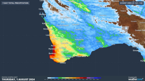
Another showery night in Perth has delivered enough rain to make this Perth’s first wetter-than-average month in more than one year. The animation below shows showers streaming over Perth and other areas of southwestern Australia late on Thursday. This wet weather was caused by persistent onshore winds along the west coast of WA, and the […]
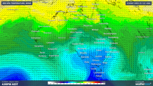
A frigid airmass originating from Antarctica is on its way to Australia on Friday, with the southeastern states expected to shiver through a prolonged cold spell. This airmass will arrive behind a cold front over the weekend and will linger over southeastern Aus well into next week. The satellite image below shows the cold front […]
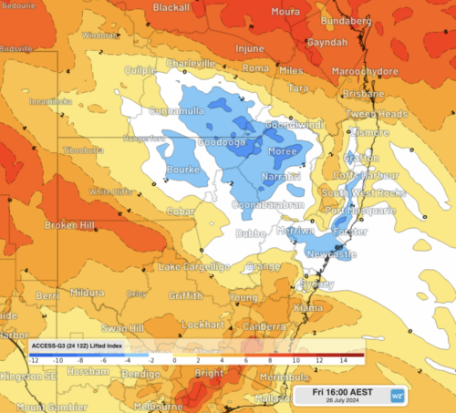
The weather is feeling quite spring-like over northern NSW and southern Queensland, with warm days, smoke from hazard reduction burns and even a chance of thunderstorms on Thursday and Friday. Northerly winds ahead of a trough and cold front are creating a very mild winter’s day, with temperatures 4-7 degrees above the July average across […]
A wet spring could be on the cards for large parts of Australia, with several models suggesting a negative Indian Ocean Dipole could develop in the Indian Ocean. A negative Indian Ocean Dipole (IOD) refers to a pattern of sea surface temperatures in the tropical Indian Ocean that causes more moisture-laden air to flow towards […]
