
Weatherzone Business supplies precise weather intelligence to over 75% of the National Energy Market (NEM); and is the trusted provider for the Australian Energy Market Operator (AEMO).
Weatherzone’s next-generation nowcasting and forecasting system, OpticastTM, is independently proven to outperform other industry models, allowing energy traders to respond rapidly to changing conditions. From 14 day forecasting to seasonal outlooks, you have access to complete and powerful weather intelligence giving you the confidence to make the best call.
Meeting the needs of the changing market, Weatherzone utilises high-resolution modelling and local knowledge to provide 5-min granularity observations and forecasts, optimising your market bidding and maximising your profits. These, coupled with briefings from our energy meteorologists, give you full awareness of the associated risk.
Benefit from specialised indices such as apparent temperature, Cooling/Heating Degree Days (CDD/HDD) and Effective Degree Days (EDD) to help accurately predict demand. You can get a clear picture of forecast conditions across the market and quickly assess heat/heatwave potential from 14 days out to 12 months
No matter where your energy trading focus lies, we have the power generation and weather insights to inform your critical decisions, keeping you ahead of the curve.

Your power generation and weather data is customisable and delivered via an easy to visualize dashboard. You will have access to comprehensive data including wind and solar generation, nowcasting and 4-week extreme weather outlook, and seasonal forecasts. This is supported by meteorologist commentary and error bounds, so you can understand the risk.
We are there for you: rain, hail or shine.
OpticastTM provides high precision, rapid-update nowcasting and forecasting data helping you to ensure predictions for the supply to market are correct.
You can speak to our energy meteorologists from 5am to 8:30pm AEST, 365 days a year, so you can access comprehensive weather data and risk analysis when you need it the most.
Weatherzone is able to provide farm level or state total wind generation forecasts, as well as solar generation forecasts for utility scale solar and rooftop PV, providing the full picture.

We thrive on challenge, next-generation science and customised service and are dedicated to helping you stay ahead of the game.
Weatherzone’s Opticast Renewable Wind (RW) wind generation forecasts produce data for individual wind farms, state level and the NEM at daily and hourly resolution. The wind farm database is regularly updated and corrected based on the latest generation detail. Gain visibility of what is occurring at individual farm and state level, and across the NEM as a whole.
Industry-leading solar information is provided in partnership with Solcast. Utilising high-resolution satellite data, NWP model inputs and PV system metadata from >850k systems Australia wide, you will have a clear picture of solar generation and provision to the NEM.
We work to bring you complete situational awareness so you can mitigate risk and maximise your profits.
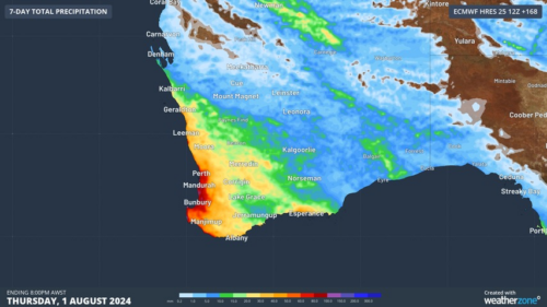
Another showery night in Perth has delivered enough rain to make this Perth’s first wetter-than-average month in more than one year. The animation below shows showers streaming over Perth and other areas of southwestern Australia late on Thursday. This wet weather was caused by persistent onshore winds along the west coast of WA, and the […]
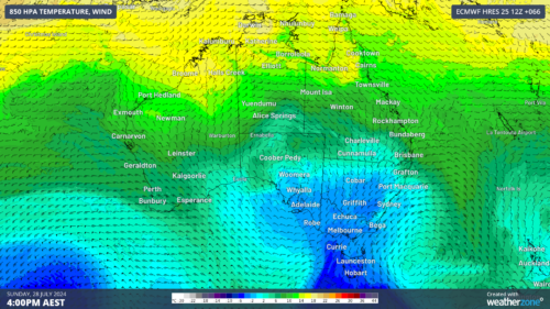
A frigid airmass originating from Antarctica is on its way to Australia on Friday, with the southeastern states expected to shiver through a prolonged cold spell. This airmass will arrive behind a cold front over the weekend and will linger over southeastern Aus well into next week. The satellite image below shows the cold front […]
The weather is feeling quite spring-like over northern NSW and southern Queensland, with warm days, smoke from hazard reduction burns and even a chance of thunderstorms on Thursday and Friday. Northerly winds ahead of a trough and cold front are creating a very mild winter’s day, with temperatures 4-7 degrees above the July average across […]

A wet spring could be on the cards for large parts of Australia, with several models suggesting a negative Indian Ocean Dipole could develop in the Indian Ocean. A negative Indian Ocean Dipole (IOD) refers to a pattern of sea surface temperatures in the tropical Indian Ocean that causes more moisture-laden air to flow towards […]
