
Aviation Watch is Weatherzone’s customisable delivery system – painting the full weather and aviation picture – purpose-built to meet the unique requirements of the airline industry.
Aviation specific information, your operational inputs, lightning and severe weather alerting, and forecasting are all seamlessly integrated on Aviation Watch’s easy-to-visualise interface.
Quick view GIS maps show the real-time and forecast conditions of every aviation port in the world. Each port’s status is shown based on the TAF/METAR conditions relative to your specific minima for ceiling and visibility.
You have access to unique timelines that effectively decode the TAF/METAR data into a visual time band – relative to the minima for that port – giving you a clear overview of how conditions are forecast to change.
You have these parameters at your fingertips, with further options available, as you customise your own dashboard:
Serving the needs of pilots, ground crew and support staff, Aviation Watch provides critical intelligence, in a format that enables quick decision making.
The efficiency and safety of your operations are fully supported by the most accurate data available. With this foresight you can assess flight paths, fueling and staffing needs with ease, and protect your passengers, staff and bottom line.

Weatherzone adheres to the standards for aviation meteorology set by the World Meteorological Organisation (WMO) and the International Civil Aviation Organisation (ICAO). Registered with the ICAO and providing safety critical OPTMET data with permission from Air Services Australia, our aviation services meet the industry’s stringent requirements.
TAF and METAR data is colour coded on GIS maps for quick and clear interpretation of any port. Coding is relative to your specific minima for ceiling and visibility.
Choose from a comprehensive offering of weather and aviation data and create a personalized dashboard with your most relevant, and easily accessed intelligence.
Protect your staff and passengers with real-time monitoring of storm activity, and the most accurate lightning proximity alerting system on the market.

Weatherzone Business’ experience and aviation services give you clear paths through complex situations. Let us assist you, offering you actionable insight when extreme weather threatens.
OpticastTM
Weatherzone operates Opticast, a consensus forecasting model able to correct NWP errors in real-time. It is independently proven to be the best performing of its type in Australia. Opticast rapid updates every 10 minutes, intelligently adapts to local observations and corrects forecasts based on historical evidence. Wherever you are, we can provide you with the most accurate nowcasting and forecasting data out to 14 days so that you can mitigate operational and safety risks, and plan to make the most of severe weather windows.
Severe Weather and Lightning Alerting
Weatherzone’s Total Lightning Network (TLN) comprises of a dense network of regional and global sensors that detect intra-cloud (IC) and cloud-to-ground lightning (CG) strikes within your proximity thresholds. Safeguard your teams and assets with lighting alerting – accurate to <200m – and Dangerous Thunderstorm Alerts (DTAs). Alerts are customised to your existing parameters and delivered in real-time across all devices in your network. You gain full spatial awareness of developing severe weather systems, allowing you to plan and, where needed, execute your diversion procedures.
Route Cut
The route cut is provided in Aviation Watch by selecting departure and arrival ports, or latitude and longitudes. Departure times and flight duration can also be entered. The route is then plotted, providing a vertical profile of the route showing winds (true), temperature and relative humidity. In the interface, these route cuts use great circle routes however, in the WxBrief app, these are generated off the actual flight plans and provide winds relative to the flight track. Any NWP model can be used.
Trusted by the aviation industry, Aviation Watch is the proven solution you can rely on, giving you full situational awareness minute by minute.
Rain, hail or shine: we are there to safeguard your staff, passengers and operations.
Thunderstorms will develop over a broad area of NSW and Qld on Thursday afternoon, with severe storms likely in some areas. Thursday’s storms will be triggered by a low pressure trough interacting with an unstable atmosphere and moisture over eastern Australia. An upper-level trough above eastern Australia will also enhance wind shear in some areas, […]
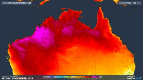
A burst of unusually hot weather will cause severe to extreme heatwave conditions across parts of three states and territories in northern Australia this week, with the heat also elevating fire danger ratings in some places. Northern Australia is certainly no stranger to heat at this time of year. The country’s highest temperature ever recorded […]

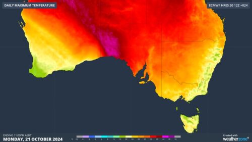
Melbourne is basking is spring-warmth today, ahead of a 10°C temperature drop tomorrow. The cities maximum is forecast to be 32°C on Tuesday afternoon, making it Melbourne’s warmest day in seven months and the first time the mercury has reached 30°C since March 18. Temps will also top 30°C across much of Victoria, with a […]
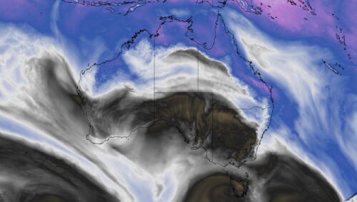
Parts of South Australia, Victoria and Tasmania will experience a burst of warm weather at the start of this week, briefly increasing fire danger ratings in some areas. The satellite images below show a cold front crossing southwestern Australia on Monday morning. Image: Visible satellite images showing clouds over Australia on Monday morning. This animation […]
