The southeastern states are set to see a significant defrosting mid this week, as a burst of warm, dry and windy conditions brings extreme fire danger to parts of NSW.
Several towns and cities have recorded their coldest spring morning on record on Monday morning, after a cold front on the weekend left an unseasonably cold airmass in its wake and skies cleared under the influence of high pressure. The spring warmth will return mid-week, as blusterous northwesterly winds drag warmth over the southeastern states ahead of a strong cold front.
The maps below show the contrasting temperatures during the beginning of the week and then mid to late week.
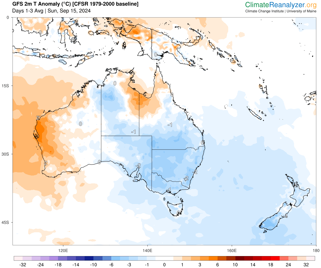
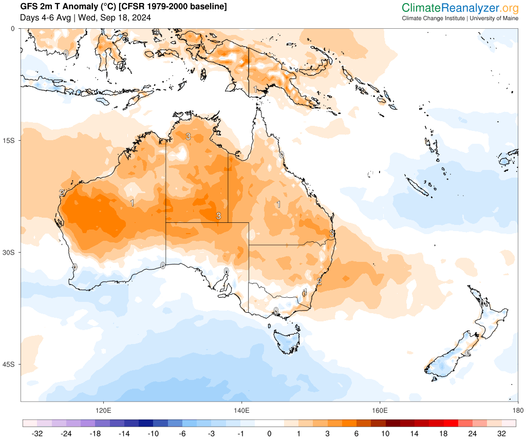
Images: 2m temperature anomaly (°C) forecasts for the three days beginning Sunday, September 15 (top) and Wednesday, September 18 (bottom), according to GFS. Source: ClimateReanalyzer.org
Spring is known for major swings in temperature and this week is no different, with daytime temperatures rising 7 to 10°C in just a few days:
- Sydney’s will see a 10°C difference between Sunday and Thursday, with the daytime temperature only reaching 16.5°C on Sunday and forecast to top 26 to 27°C on Wednesday and Thursday.
- Brisbane is forecast to reach 23°C on Monday and 30°C on Thursday and Friday, a 7°C temperature difference.
- Adelaide’s temperature should only reach 16°C on Monday, with the maximum forecast to hit 23°C on Wednesday, another 7°C temperature increase.
- Melbourne’s maximum was a chilly 10.8°C on Saturday and is forecast to reach 21°C on Wednesday, a 10°C temperature jump.
The warm weather will be accompanied by strong westerly winds on Wednesday and Thursday, with the potential for damaging winds across several states and territories.
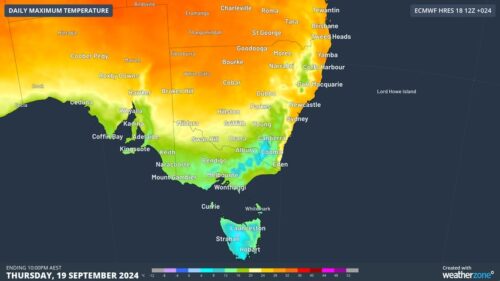
The map below shows strong westerly wind gusts across much of the southeastern states on Thursday afternoon.
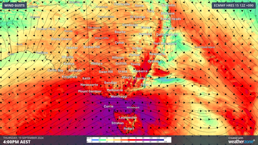
Image: Instantaneous wind gust forecast for 4pm Thursday, September 19, according to ECMWF
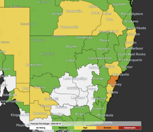
The warm, dry and windy weather will also elevate fire danger across parts of Qld and NSW on Wednesday and Thursday.
High fire danger is forecast on Wednesday in the Sydney, Hunter and Illawarra regions, before fire danger becomes extreme in Sydney on Thursday. Parts of southern inland Qld will also see high fire danger on Thursday.
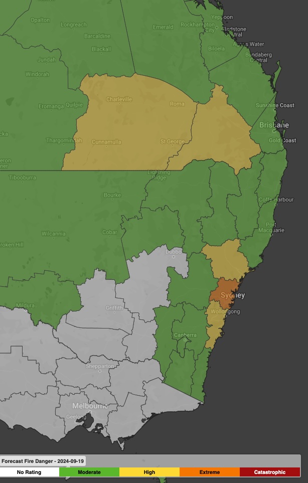
Image: Forecast fire danger for Thursday, September 19 showing extreme fire danger is forecast for the Sydney region.
This will be the second early season extreme fire danger NSW has seen ahead of the usual fire season start in October.
Please keep an eye out for the latest warnings and forecasts as this system unfolds.
Weatherzone Business has grown to become the outright leader within the Australian energy market, serving wind, solar, hydro, trading, utilities and network companies.
You can’t control the weather, but you can gain precision insights to optimise your response. What lights us up is providing your energy business with tailored weather information to reduce your risk and keep you moving ahead of the curve.
Our services cover all aspects – from wind and solar generation to demand forecasts, wholesale markets to retail so, no matter where your company sits, we have solutions for you. We have worked closely with market participants to create products that meet the evolving needs of the sector, aiming to increase safety and profitability for our customers.
Benefit from the timely delivery of accurate weather information, allowing informed and effective decision-making. For more information, please visit our website or email us at business@weatherzone.com.au.