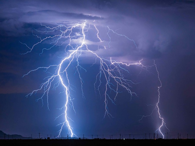
Rare outbreaks of thundersnow, inversion lightning, and even a squall line have all hit NSW in the past 24 hours, as an unusually active winter storm system sweeps over the state.
Thundersnow
A rare outbreak of thundersnow has developed over the Australian Alps on Tuesday afternoon, as a brief burst of heavy snowfalls was accompanied by multiple lightning strikes.
As you can clearly see on the graphic below taken at 2:30 pm AEST, numerous lightning strikes occurred as a cold front crossed the mainland alpine region accompanied by heavy snowfalls.
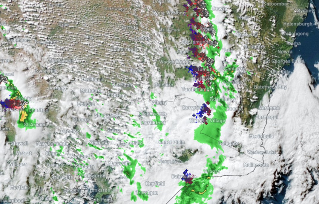
Look closely towards the top of the green precipitation blob straddling the NSW/Vic border and you can see a large agglomeration of strikes situated right over Thredbo Village, which is just a few kilometres south of Mt Kosciuszko.
Yes, we’ve seen thundersnow this Tuesday on the very rooftop of Australia. And if you’re wondering how we know it was snowing at the time, here’s a pair of time-stamped snow cam images to prove it!
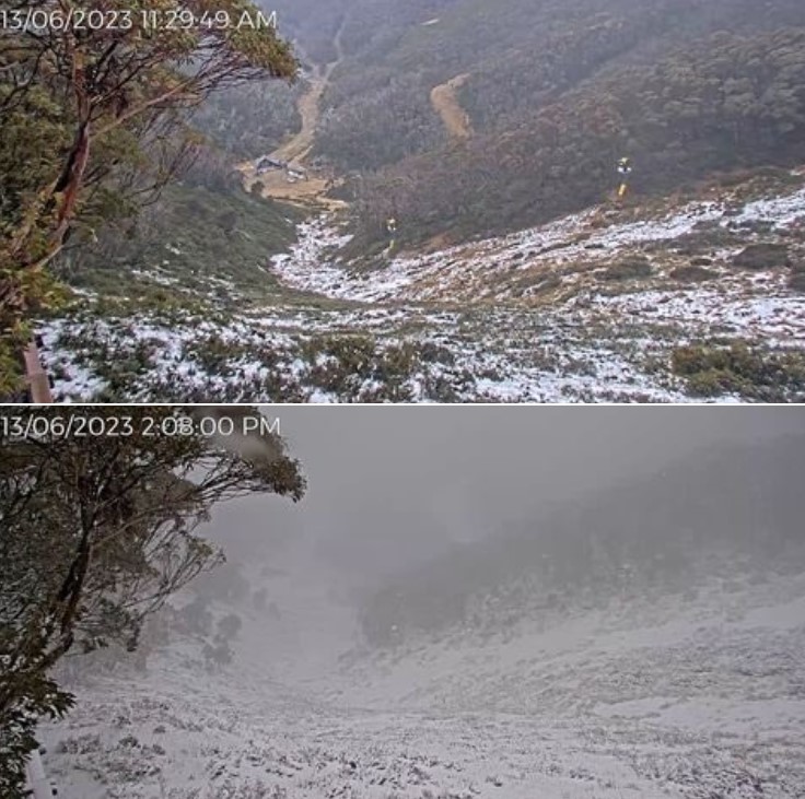
Image: This pair of images taken less then three hours apart is actually from Mt Hotham in Vic. Lightning also moved through the Vic Alps en route to the NSW Snowy Mountains. Source: ski.com.au.
Now as any weather-lover knows, thunderstorms and lightning are usually associated with warm air.
So how do thunder and lightning happen when it’s cold enough for snow?
Weatherzone meteorologist Ben Domensino explains:
“With most thunderstorms, you have relatively warm air sitting below cooler air, which creates an unstable atmosphere and causes the warmer air to rise.
In snowy areas, there is generally only a small temperature contrast between the surface and upper levels, so there’s usually not enough instability to create the uplift needed for thunderstorm development.
But when you’ve got a very cold airmass, there can be enough of a temperature contrast between surface and upper level temperatures to make storms.”
In the case of the current event, it’s also likely that precipitation cooling effect kicked in, lowering the air temp and snow level as the short-lived but intense storm passed through the mountains.
Meanwhile, all mainland alpine resorts are reporting subzero temps by 3:30 pm in the wake of Tuesday’s cold front. That said, the coldest air is still to arrive, and the snow level should drop to around 1000 meters above sea level this evening as further bands of showers arrive.
Around 10 to 20 centimetres of snow is expected from this current system at higher levels. That, combined with snowmaking, should be enough to crank up lifts on beginner slopes at all resorts, after a disappointing opening weekend with no skiing or boarding at most resorts.
Inversion Lightning
An “absolutely enormous” clap of thunder caught residents in Sydney’s Northern Beaches by surprise on Monday night as a lone cloud-to-ground lightning strike produced rare inversion thunder.
All lightning causes thunder when the incredibly high temperature of the lightning bolt causes the surrounding air to rapidly compress, creating a shockwave that propagates outwards in all directions.
If the lightning that produced the thunder is a long way from your ears, the sound it produces has plenty of time and space to spread out and bounce off objects in the sky and on the ground. This makes distance lightning sound like a long, low rumble by the time it reaches your ears.
On the other hand, when lightning occurs close by, the sound reaches you quickly without dissipating, which often makes it sound like a louder crack or clap.
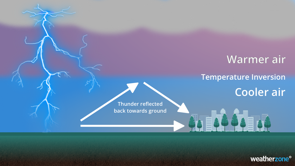
However, there is an even louder type of thunder that can only occur under the right conditions. It’s called ‘inversion lightning’ and it happens when a lightning strike hits the ground beneath a temperature inversion.
A temperature inversion occurs when cold and dense air sits below a layer of warmer air in the lowest layer of the atmosphere. These temperature inversions can trap air and sound near the ground, preventing them from dissipating upwards through the atmosphere.
When lightning occurs beneath an inversion, the thunder it produces can bounce off the temperature inversion and the sound propagates horizontally. Inversion thunder can be much louder and travel longer horizontal distances than regular thunder. It is also more common and night and during winter, because this is the most likely time for inversions to form.
On Monday night, a temperature inversion above eastern NSW caused inversion thunder that could be heard loudly across parts of Sydney’s Northern Beaches, with residents in the area describing the thunder as “a single absolutely enormous lightning bolt”.
Weatherzone’s Total Lightning Network detected a single cloud-to-ground lightning strike between Forestville and Lindfield at 8:30pm AEST on Monday, June 12. This is likely the strike that caused the inversion thunder.
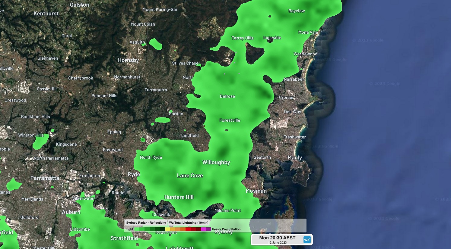
Image: Observed lightning and rainfall at 8:30pm AEST on Monday, June 12, 2023.
Squall Line
A squall line has developed over NSW on Tuesday afternoon, producing widespread wind gusts in excess of 80km/h.
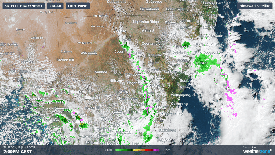
Image: A squall line sweeping over NSW between Coonamble and Merimbula on Tuesday afternoon.
Squall lines are a powerful form of thunderstorms that allows a set of thunderstorms to join together and create a single, self-sustaining system that crosses vast distances. Squall lines are commonly associated with large-scale damaging wind gusts, as is the case in NSW this Tuesday afternoon.
Read more: What is a Squall Line?
This squall line has produced the strongest wind gusts in two and a half years at Nerriga, gusting to 100km/h at 4:39pm in the afternoon.
Some more powerful gusts occurred within minutes of one another, despite being separated by hundreds of kilometres apart. Some such pairs of gusts were:
- 95km/h Thredbo at 4:17pm and 85km/h Dubbo at 4:20pm
- 98km/h Moss Vale at 5:12pm and 87km/h Nowra at 5:12pm
- 82km/h Jervis Bay at 5:30pm and 69km/h Mudgee at 5:30pm
These gusts were all brought on by the same squall, showing how widespread these storms really are.
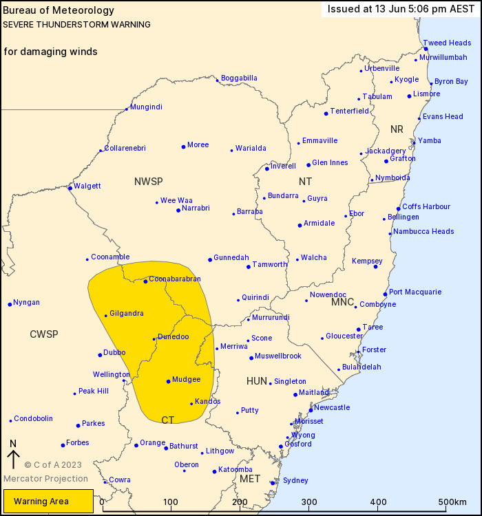
This squall line is continuing to cross the state as this is written (~6pm) with a Severe Thunderstorm Warning current for parts of the Hunter, Central Tablelands, North West Slopes and Plains and Central West Slopes and Plains Forecast Districts.
How Weatherzone can prepare you for Thunderstorms
Weatherzone Business can help your business deal with thunderstorms through:
- Accurate and easy to understand forecasts beforehand
- Thunderstorm tracking and Lightning Alerting during a storm
- Event and Lightning reporting afterwards.
Our colossal influx of data from all the worlds leading weather forecast models and the Weatherzone Total Lightning Network gives us a unique ability to prepare your business for thunderstorms like no other. To find out more, please email us at business@weatherzone.com.au.