
High-Resolution Modelling
Oracle is a satellite-derived, gridded nowcasting system. It forecasts out to 3 hours at a 1-2km resolution, and rapid updates every 5 minutes. With this enhanced forecasting detail, Oracle has the upper hand over 9-12km resolution models when capturing temperature, lightning, cloud cover, wind and rainfall. This ensures that no matter where you are in Australia, you will have access to precision nowcasting and forecasting that can rapidly inform your critical business decisions.
Greater Situational Awareness
Working in conjunction with Weatherzone’s Stormtracker GIS system, Oracle provides full situational awareness of any severe weather event that presents risk to your business. Short-term forecasting and severe weather alerts enable you to foresee the intensity and duration of events, so you can prioritise the safety and preparation of your staff and assets.
Whatever the weather, we provide the insights to help keep you and your team safe, productive and profitable.

Oracle is the solution to visualising rainfall and severe weather across the whole of Australia. Let us give you the situational awareness and analytical insight needed to make the best decisions for your business.
Let us give you the analytical insight needed to make the best decisions for your business.
Oracle works beyond the existing radar system and extends across the most remote parts of Australia, so no matter where you are, you can see what’s on the horizon.
When extreme temperatures, severe weather and heavy rainfall affect your operations, Oracle delivers insight and alerts, buying you the time to prepare and take action.
Gain a visual understanding of current conditions. Oracle is the market-leading nowcasting system that facilitates making informed critical decisions quickly.

When a severe weather system is heading straight for you, our team of qualified meteorologists dissect the data around the clock to give you actionable solutions.
You don’t need to weather the storms alone. We can help you break down the timeline, so that you can approach your preparations in the most practical way, deciding on how best to manage the immediate risk.
Weatherzone Business’ experience and intelligence gives you a clear path through a complex situation. Let us assist you in making the best possible assessment of risk to your business when extreme weather threatens.
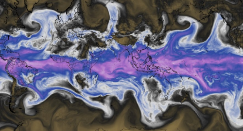
Earth just had its most moisture-laden April on record as unrivalled air and ocean temperatures caused atmospheric moisture content to surge across the planet. It has been known since the 1800s that rising global air temperature allows Earth’s atmosphere to hold more moisture. This phenomenon is explained by the Clausius–Clapeyron relation, which shows that the […]
Solar output in the east has taken a hit recently, with more cloud to come, but the wind has picked up, keeping renewable penetration stable in the market. The image below shows thick cloud over the eastern half of the country on Thursday afternoon. Image: Himawari-9 satellite image at 12pm AEST on Thursday, May 9. […]

Widespread rain and thunderstorms will spread over Australia’s eastern inland over the next few days, before drenching already sodden parts of the NSW coast this weekend. The atmosphere above eastern Australia is being loaded with moisture this week thanks to the influence of a stubborn high pressure system centred to the south of the country. […]
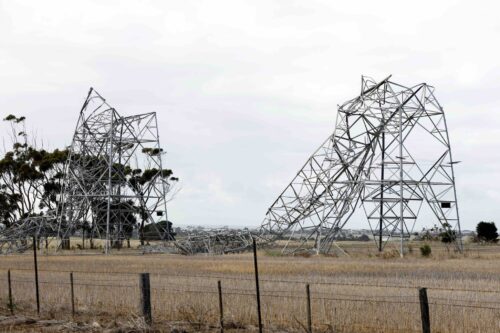
Earlier this year destructive thunderstorms and winds equivalent to a category two cyclone lashed Victoria, bending towers and toppling trees and poles. So, how can thunderstorms damage energy infrastructure, and are these events getting worse? This event occurred during mid-February 2024, when a strong cold front generated severe thunderstorms and localised wind gusts of 130km/h […]
