Australia’s severe thunderstorm season is about to begin. But with a looming El Niño and positive Indian Ocean Dipole, what can we expect to see across the country this season?
Thunderstorms impact Australia all year round. They are most common in eastern and northern Australia, where there is just the right mixture of heat and humidity to fuel these storms.
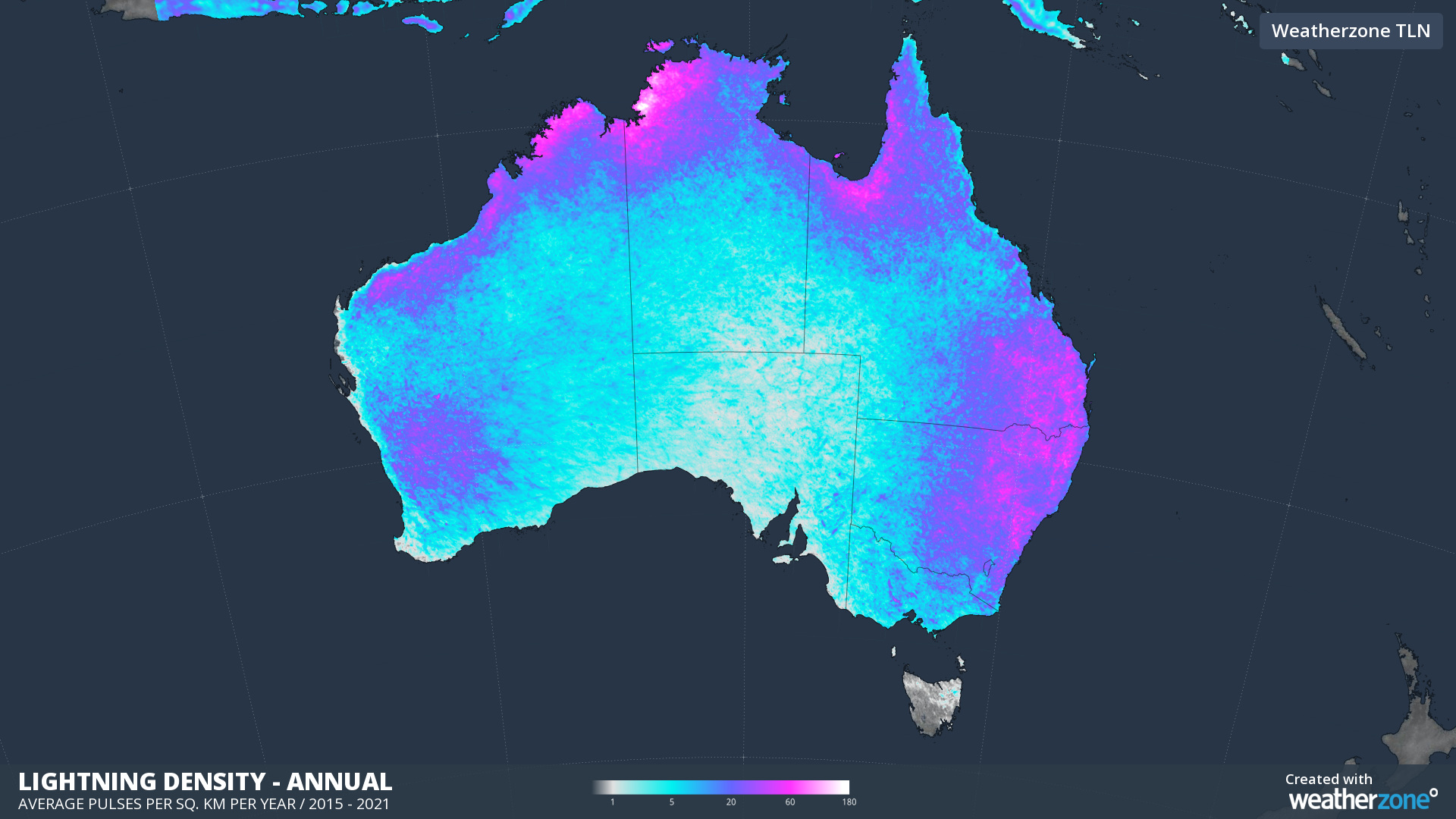
Image: Annual mean lightning density based on all lightning pulses detected by Weatherzone’s Total Lightning Network between 2015 and 2021.
While storms occur through the year, the peak storm season in Australia occurs during the warmer months of the year between September and March. The most lightning-active areas in Australia are in the northern tropics, and from southeastern Qld down to central NSW.
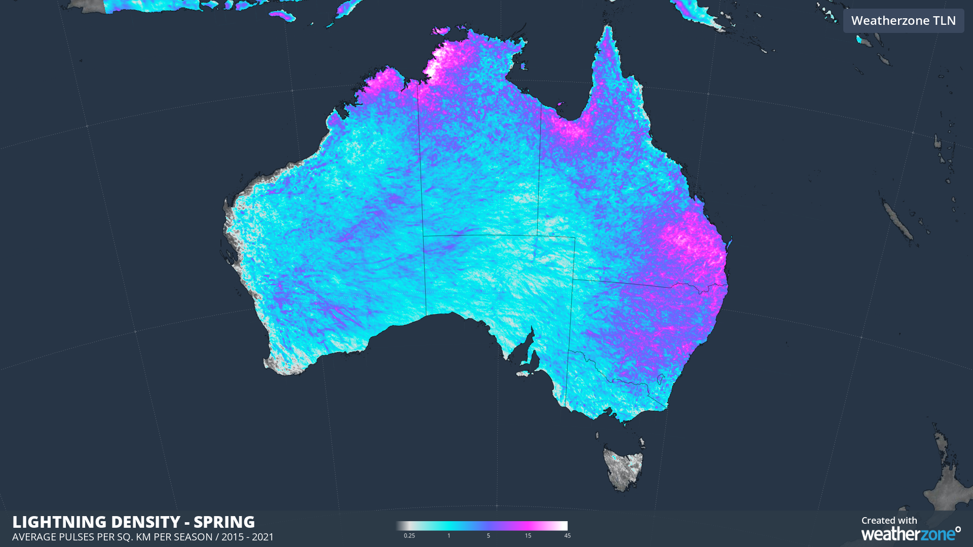
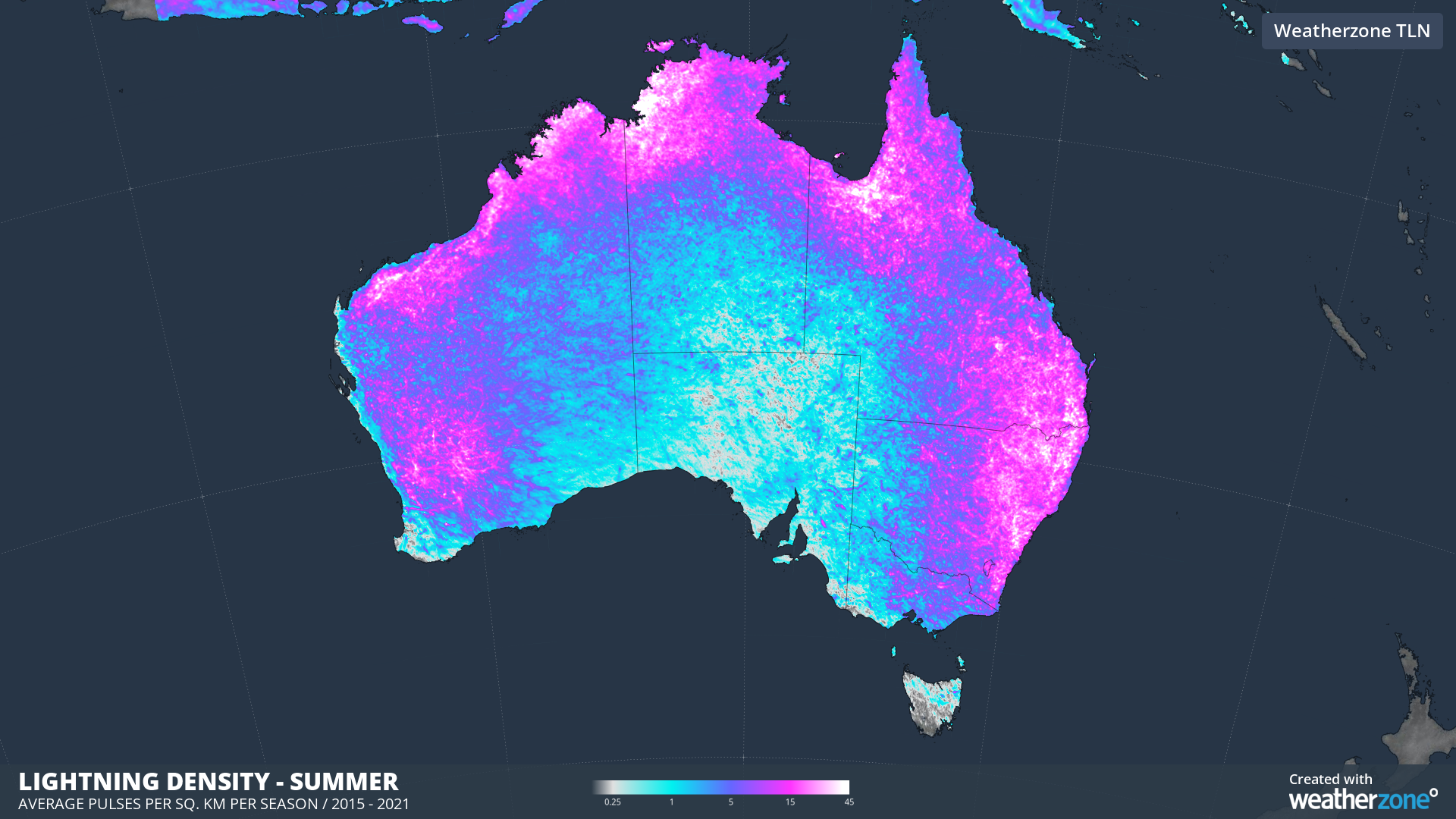
Images: Mean lightning density in spring (top) and summer (bottom) based on all lightning pulses detected by Weatherzone’s Total Lightning Network between 2015 and 2021.
Thunderstorms happen over large areas of Australia every spring and summer and require three key ingredients to develop:
- Moisture – Sufficient moisture in the lower levels of the atmosphere.
- Instability – An unstable atmosphere.
- Trigger – A trigger mechanism to initiate the storm.
Australia could see three dry-phase climate drivers influencing the weather this spring and potentially summer.
- El Niño is likely to develop to the northeast of Australia during spring and may persist into summer
- A positive Indian Ocean Dipole (IOD) to the northwest of Australia should develop in early spring and may linger into early summer.
- A negative Southern Annular Mode (SAM) to the south of Australia will become more likely if El Niño develops
All three of these climate drivers can change the mix of thunderstorm ingredients across Australia.
Moisture
During Spring and Summer, El Niño, positive IOD and negative SAM usually decrease the amount of moisture available to fuel storms across much of Australia, particularly the central and eastern half of the country.
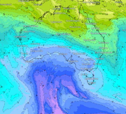
However, the map below shows that sea surface temperatures (SSTs) in late winter across eastern Australia were warmer than average, despite El Niño.
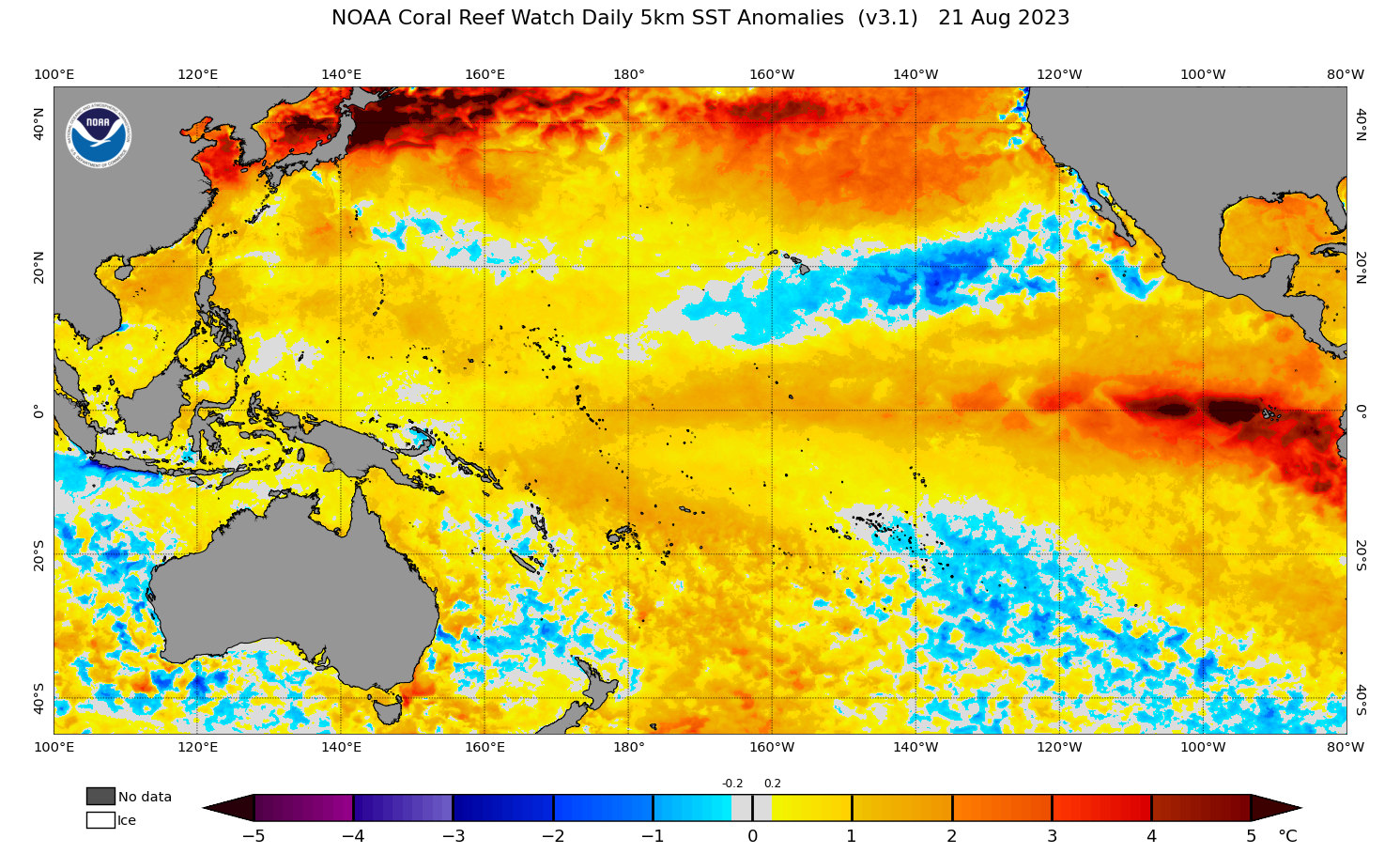
Image: Sea surface temperature anomalies on August 21, 2023. Source: NOAA
These warm SSTs near eastern Australia may increase the amount of atmospheric moisture available to thunderstorms in NSW and Qld, by providing the storms with additional fuel.
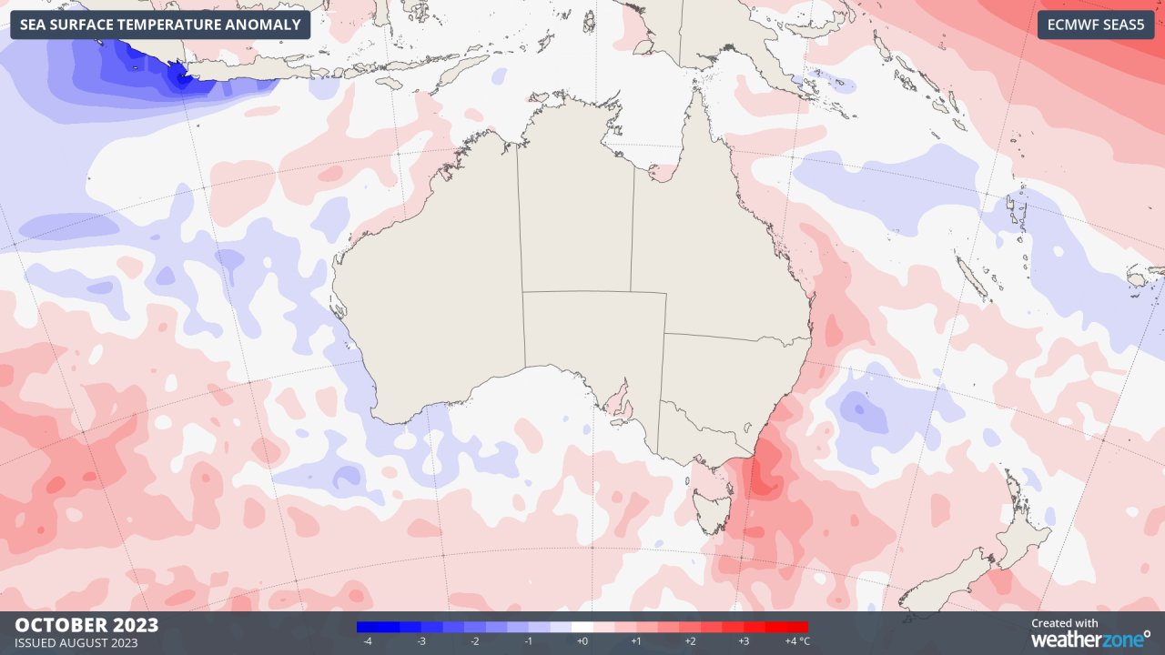
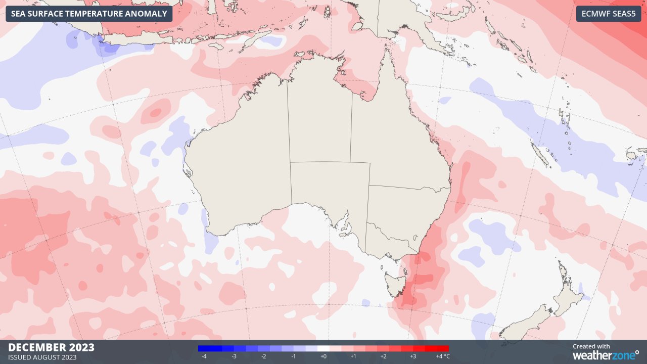
The maps below show that the models are forecasting abnormally warm SSTs to linger off the east coast for much of spring and summer, which is unusual for El Niño and positive phases of the IOD.
Instability and triggers
El Niño can increase the instability needed for storm development by increasing surface air temperature. When the lower atmosphere is warm, this can create instability, causing pockets of warm air to rise and produce clouds and eventually lightning.
During the warmer half of the year, there is also a tendency for weather systems to be more mobile during El Niño years, with cold fronts and low-pressure systems sweeping across the south of the continent regularly. These transient fronts and lows can help increase thunderstorm frequency.
What to expect this storm season
Australia will be affected by several dry-phase climate drivers in the second half of 2023. These climate drivers typically reduce moisture in the atmosphere, which can hinder thunderstorm development in some parts of Australia. However, this will be partially offset by increased temperatures and instability, and warmer-than-average sea surface temperatures near the Australian continent.
As a result, thunderstorm activity should be near average in Australia over the next few months, with localised areas of enhanced and suppressed storm activity. One area that may see more storms than a typical El Niño is far eastern Australia, due to the unusually warm sea surface temperatures near the coast.
El Niño can also change the spatial distribution of thunderstorms in Australia, typically causing eastern Australia’s peak thunderstorm activity to shift further north into tropical Qld, and further west over Qld and NSW.
Severe Thunderstorms
If negative phases of the Southern Annular Mode occur frequently in the coming months, we could see an increase in the number of severe thunderstorms in southern Australia. The most likely severe phenomenon in this region would be damaging or destructive winds and large hail, as cold fronts pass further north than normal.
Dry lightning
The warm and dry forecast for Australia also means that dry lightning could be more prevalent this season, which could increase the bushfire risk across the country.
Are you safeguarding your utilities assets and personnel from the threat of increasingly volatile weather?
Weatherzone Business, a DTN company, offers precise weather intelligence and alerting to protect your utilities network when severe weather, floods and fires threaten.
Over 80% of Australian transmission and distribution networks already rely on our proven nowcasting and forecasting out to 15 days. You can rest assured yours is protected by market-leading analysis. With this foresight you can gain lead time to prepare for possible outages, reduce risk and protect your people and profits.
You will never be left in the dark when conditions suddenly worsen. We deliver reliable, up-to-the-minute weather forecasts and analytical tools that give you the power to enhance your operational management and response to weather risk. Our Total Lightning Network is a globally proven solution that accurately identifies and alerts you to lightning strikes within your defined thresholds, supporting the safety of your team.
Your customisable interface has GIS mapping, showing multiple weather layers over your utilities network and offering full situational awareness. You can quickly recognise any threat to your assets in real-time. 24-hour asset monitoring allows you to track lightning, bushfires and other severe weather systems that approach your service territory.
Advanced and actionable analytics allow you to act decisively and improve your planning and outage response strategy. For more information, please contact us at business@weatherzone.com.au.