
The Insurance Industry has seen a spate of severe weather events since 2010, including flooding through Brisbane, major hailstorms in both Perth and Melbourne, plus widespread damage related to the landfall of Tropical Cyclone Yasi.
The 1999 Sydney hailstorm still ranks as the costliest natural disaster in Australian history, with an estimated $1.7 billion dollar cost to the insurance industry.
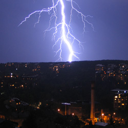
Given these recent costly events, Weatherzone has developed multiple tools to reduce impacts on the Insurance industry, including the deployment of Australia’s most advanced lightning network, with nation-wide coverage.
The unique ability of the new Weatherzone Total Lightning Network (WZTLN) to comprehensively detect both cloud-to-ground and cloud-to-cloud strikes at street level accuracy is unrivaled in the Australian market. This ability to detect cloud-to-cloud strikes in a developing thunderstorm can mean up to 15 minutes more lead-time than other alerting methods, whilst specialist software tools for predicting the severity of the storm are also available. This means greater lead-time for alerting your Insurance customers of severe weather, so that evasive action can be taken, thus reducing the eventual damage bill.
Additionally, geo-tagged severe weather forecasts from Weatherzone’s meteorology team provides the Insurance industry a new level of visibility for decision-making, days in advance. Examples of the forecast products and benefits are listed below:
- Heavy rain risk for capital cities, to be used by car insurers when planning call centre staff numbers and assessing short-term pricing
- Flood risk due to the combination of forecast heavy rainfall and current river levels, so that insurance companies can plan when to implement embargos on new policies
- Bush Fire Risk due the combination of forecast heat, wind and humidity (Fire Danger Index factors), again for embargo related purposes
Weatherzone is pleased to partner with many of the leading insurance and re-insurance agencies in Australia to find innovative solutions to the challenges posed by Australia’s erratic weather.