Signs are pointing to the second consecutive positive Indian Ocean Dipole (IOD) developing in the next few months. However, May is shaping up to be a time to make-or-break this event.
What is a positive IOD?
The IOD is a coupled ocean-atmosphere climate driver that changes the circulation patterns over the Indian Ocean. A positive IOD occurs when colder waters are upwelled (brought from below to the surface) in the eastern Indian Ocean near Jakarta, forcing warmer waters to travel west, where they build up near Africa. The cold water in the east reduces atmospheric moisture, leading to clearer skies and stronger southeasterly winds in the eastern Indian Ocean and the Australian continent. These winds then help to continue the upwelling of more cold water.
Meanwhile, near Africa, warm waters boost convection, increasing rain and thunderstorms, helping draw more air in from the east. This positive feedback loop allows an established positive IOD to become stronger and self-sustaining.
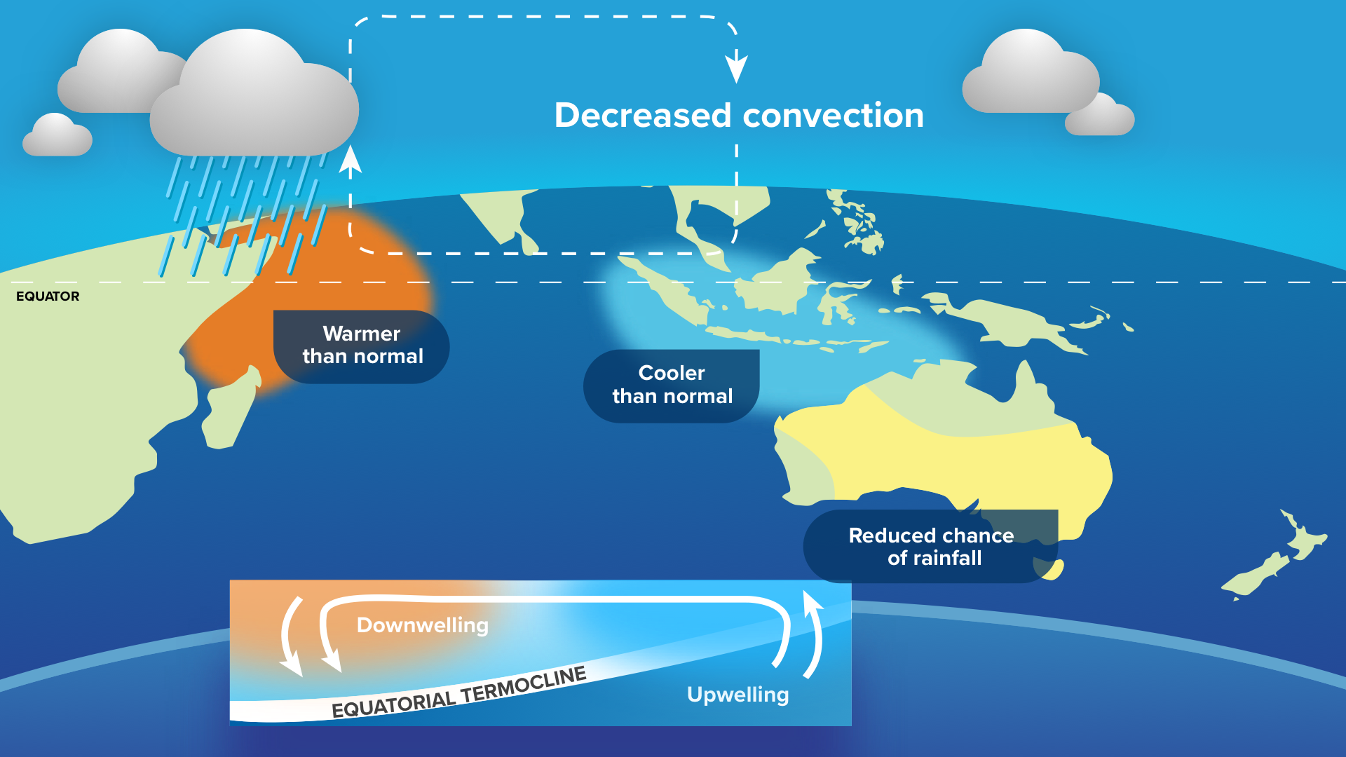
Positive IOD events typically reduce the amount of moisture that flows from northwest Australia to the southeast of the country. This leads to clearer skies, reduced rainfall, and increased daytime temperatures during winter and spring. Minimum temperatures typically increase in spring throughout Australia with a positive IOD, but they decrease in the southeast during winter under clearer skies, increasing the occurrence of frosts.
Recent positive IOD events were in 2019 and last year in 2023, both of which featured very dry periods in late winter to mid-spring. Note that if a positive event forms this year, it will be the first time since records began in 1960 that we have seen two consecutive positive IOD events.

Image: Standard rainfall anomaly over Australia from August to October 2023 as the positive Indian Ocean Dipole developed. Source: Climate Change Institute, University of Maine
How close are we to a positive IOD?
Like the Niño3.4 index used to monitor the El Niño Southern Oscillation in the Pacific Ocean, the Indian Ocean has an equivalent index, simply named the IOD Index. This index compares the relative ocean temperatures in the western (near the Horn of Africa) and the eastern (near Jakarta, Indonesia) Indian Ocean. When this index is above +0.4°C for at least 3 consecutive months, it is a sign that a positive IOD is underway.

Over the past 7 weeks, the IOD Index has been above +0.4°C and is currently sitting at a value of +0.68°C. If the index keeps this up over the next 5 or so weeks, it is likely that a positive IOD event will be declared.
How certain is it that a positive IOD will form?
A critical time in the development of this IOD event is approaching in mid-to-late May. This event is a strong pulse of the Madden-Julian Oscillation, a pulse of tropical activity that circumnavigates the globe near the equator. During an active pulse, tropical activity increases, and the result can alter both ocean and atmospheric patterns.
It is well documented and researched that this kind of tropical activity can act for or against particular phases of the IOD. Over an active area of tropical activity, especially if a tropical cyclone forms, air is constantly rising, and cold water is helped to upwell underneath. If this converging air and cold-water upwelling occurs in certain locations in the Indian Ocean, it can amplify or dampen the establishing IOD circulation.
For example, if a tropical cyclone develops in the Bay of Bengal during the months of April or May, there is a very high likelihood that a positive IOD event will occur in that year. This is because it draws moisture away from the ‘upwelling zone’ labelled below, setting up the circulation necessary for a positive IOD.
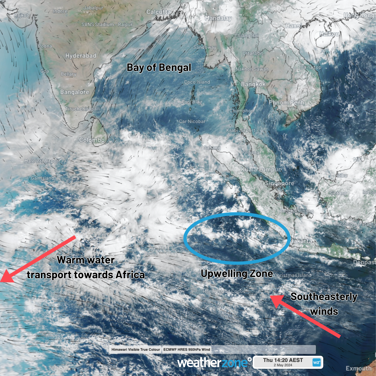
Around mid-May, a pulse of the MJO will pass over the eastern Indian Ocean. If significant tropical activity occurs near India or near Australia, this positive IOD event will become far more likely to occur. Conversely, if significant activity occurs over Indonesia, and specifically in the ‘upwelling zone’ near Jakarta, it may act to hinder the formation of the positive IOD.
The occurrence of this tropical interference leads to the ‘autumn predictability barrier’, a term to reflect how climate driver forecasts at this time of year have reduced accuracy. Any tropical activity forming in particular locations in the Indian Ocean, as well as other ocean basins, may interrupt the establishing circulation, and lead to a sudden shift in climate driver expected for the remainder of the year. This barrier applies in the Pacific Ocean with the El Niño Southern Oscillation for the same reasons.
So far in 2024, there are strong signs that a positive IOD is forming, with southeasterly winds in the east, and warm waters built up in the west. However, it is too soon to say with certainty that one will develop this year, but we should have a good idea if it will by the end of the month.
Weatherzone Business can provide tailored climate briefings to your business to alert you of the most likely weather conditions and hazards to look out for during the upcoming season from a wide variety of international sources. Now is a good time to get a good look at the forecast for summer and a look into 2024. To find out more or to book a presentation, please email business@weatherzone.com.au.


