Three South Australian towns have shivered through their coldest April night in 25 years as a near-stationary high pressure system centred over southeastern Australia made for windless, chilly nights over the weekend and into Monday morning.
The three locations with the 25-year April lows were:
- Edithburg, which got down to an impressively low minimum of 5.8°C for a coastal town on the Yorke Peninsula.
- Parafield Airport, which is in the north of the Adelaide metropolitan area, so its low of 2.5°C tells you that it was a frigid old night in the city, even though the official minimum at the West Terrace weather station was 6.3°C.
- Kingscote Airport, which is located just far enough inland from the seaside town of Kingscote (the largest settlement on Kangaroo Island) to negate the full effect of the ocean’s warmth. It dropped to 1.4°C.
None of these readings were the coldest in the state to 9 am Monday. That title goes to Keith in the state’s Upper South East forecast district, where frost warnings were in place as Weatherzone meteorologist Quincy Tut reported on Sunday, and with good reason.
The town of Keith got down to –1°C this Monday morning, its coldest April reading in 11 years and its second subzero night on the trot.
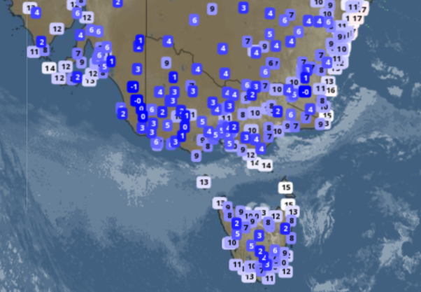
Image: Live temps at 6 am Monday, April 22 across SE Australia. You can see the minus one at Keith in SA, just west of the Vic border.
The –1°C reading at Keith wasn’t quite the coldest overnight temperature anywhere in Australia. That was –1.3°C at Cooma Airport, east of the Snowy Mountains.
In autumn and winter, Cooma and even Canberra sometimes get colder than locations up in the mountains. When that happens, it’s usually due to winds at higher altitudes, and that’s what happened last night, with Perisher Valley dropping to zero by 9 pm in still conditions before warming slightly as a light breeze kicked in.
The same effect occurred in Victoria, with temperatures plummeting perilously close to zero in the Wimmera and Mallee districts of the state’s west, while the lowest in the Victorian Alps was a relatively mild 4.4°C at Mt Hotham.
Several Tasmanian locations came close to zero overnight, but none quite reached the magic freezing mark, and while we have no statistics on this, we’d imagine it’s quite rare for the lowest minimum in South Australia to fall below the coldest recorded low temp in Tasmania.
South Australians can expect a warm day today and a warmer Monday night ahead of a cold front extending across the south of the state on Tuesday.
Weatherzone Business has grown to become the outright leader within the Australian energy market, serving wind, solar, hydro, trading, utilities and network companies. For more information, please contact us at business@weatherzone.com.au.