Australia’s southeastern states have been stuck in a pattern of frequent cold fronts since the end of May, keeping winds strong and wind power output high for most days this past week.
This spell of windy weather now looks likely to continue for at least another week, with several cold fronts set to sweep across southern Australia during the 2nd week of winter.
The windiest days across southern Australia are expected on the weekend and possibly into next week across parts of southwestern WA.
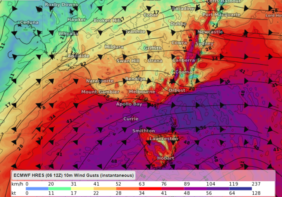
The map below shows the instantaneous wind gust forecast for Saturday evening, with strong winds impacting southeastern Australia.

Image: EMWF instantaneous wind gusts at 7pm Saturday, June 12
While a week of significant wind power is on the cards, the winds are forecast to reach damaging strength across several states and territories at times over the next week.
Is this wind too strong for wind farms?
Strong winds are usually great news for wind farms. However, sometimes the winds are too strong. There is a sweet spot when it comes to wind power.
Wind gusts above 90km/h (25m/s) can damage the wind turbines and the propellers if they are spinning in these winds.
Most wind farms turn off the turbines if the wind speed reaches the ‘cut off’ wind speed of 90km/h (25m/s) to prevent damage to the turbines.
Unfortunately, if the propellers are turned off on the turbines due to high winds, wind power is not being harnessed. During these periods of intense winds, wind power capacities will be reduced as long as the turbines remain turned off.
During the next 48 hours or so, wind speeds should be strong but not strong enough for cut offs. However, from Thursday gusts could exceed the criteria forcing some wind farms to turn the propellers off and reducing the capacity.
Weatherzone Business, a DTN company, offers wind and power generation forecasting to assist in determining your wind farm’s output, reducing costly error. For more information, please contact us a at business@weatherzone.com.au.