
The shifting climate is bringing increasingly severe weather events, so it’s time to safeguard your business against the potential damage lightning can cause.
Our Total Lightning Network is the intelligent solution that goes above and beyond to increase your lead time before the storm hits.
We ultilise a vast global sensor network, created with our partner Earth Networks. Over 1200 sensors in 40+ countries provide a worldwide view of both intra-cloud (IC) and cloud-to-ground (CG) lightning strikes, enabling businesses to plan and respond with the most precise insight available.
Offering unsurpassed accuracy, with real-time detection to <200m, we integrate with your existing systems to keep your enterprise operating within your defined severe weather thresholds.
Leave nothing to chance. Be confident working outdoors with the most sophisticated lightning alerting system, delivering intelligence to any device across your business network.

The Total Lightning Network is a high precision solution to manage the threat of severe storm damage to your business. The highest density of sensors across Australia and the globe give you the edge.
Real-time detection and alerting enhance safety outcomes whilst also preventing costly shutdowns caused by inaccurate sensor data.
You will be supported by the dedicated Weatherzone Business team, who are driven to make your operational decisions easier.
Severe weather alerts are issued via our Weatherguard app to any device across your business, allowing everyone to plan and respond quickly.
Stormtracker, our Geographic Information System (GIS), plots live lightning strikes to enhance your immediate spatial visualisation of storms.
The Total Lightning Network is meticulously maintained, ensuring efficiency and accuracy, and a system uptime of 99.9%.

The Total Lightning Network is a key consideration across many industries. If your business or supply chain operates out in the open or in the air, your company could be at risk.
Visualise approaching storms as our customisable GIS system, Stormtracker, plots lighting strikes across your site and infrastructure. This enables enhanced understanding of the potential risk inherent in each severe weather system. Personal push notifications give users real-time severe weather and lightning alerts, based on their phone’s GPS position, enhancing their awareness of personal risk.
Lightning strike history is archived for over 5 years, enabling you to extract the reportable data required for risk assessments or insurance claims.
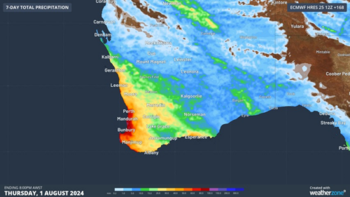
Another showery night in Perth has delivered enough rain to make this Perth’s first wetter-than-average month in more than one year. The animation below shows showers streaming over Perth and other areas of southwestern Australia late on Thursday. This wet weather was caused by persistent onshore winds along the west coast of WA, and the […]
A frigid airmass originating from Antarctica is on its way to Australia on Friday, with the southeastern states expected to shiver through a prolonged cold spell. This airmass will arrive behind a cold front over the weekend and will linger over southeastern Aus well into next week. The satellite image below shows the cold front […]
The weather is feeling quite spring-like over northern NSW and southern Queensland, with warm days, smoke from hazard reduction burns and even a chance of thunderstorms on Thursday and Friday. Northerly winds ahead of a trough and cold front are creating a very mild winter’s day, with temperatures 4-7 degrees above the July average across […]
A wet spring could be on the cards for large parts of Australia, with several models suggesting a negative Indian Ocean Dipole could develop in the Indian Ocean. A negative Indian Ocean Dipole (IOD) refers to a pattern of sea surface temperatures in the tropical Indian Ocean that causes more moisture-laden air to flow towards […]
