Rain will soak parts of WA over the coming week, although forecast models are struggling to agree on whether this burst of wet weather will bring much-needed rain to parched Perth.
This rainfall will be caused by a low pressure trough extending from the Kimberley down to southwestern WA from late Thursday, with a low pressure system developing within it early to mid-next week.
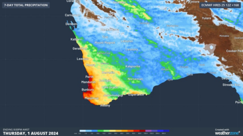
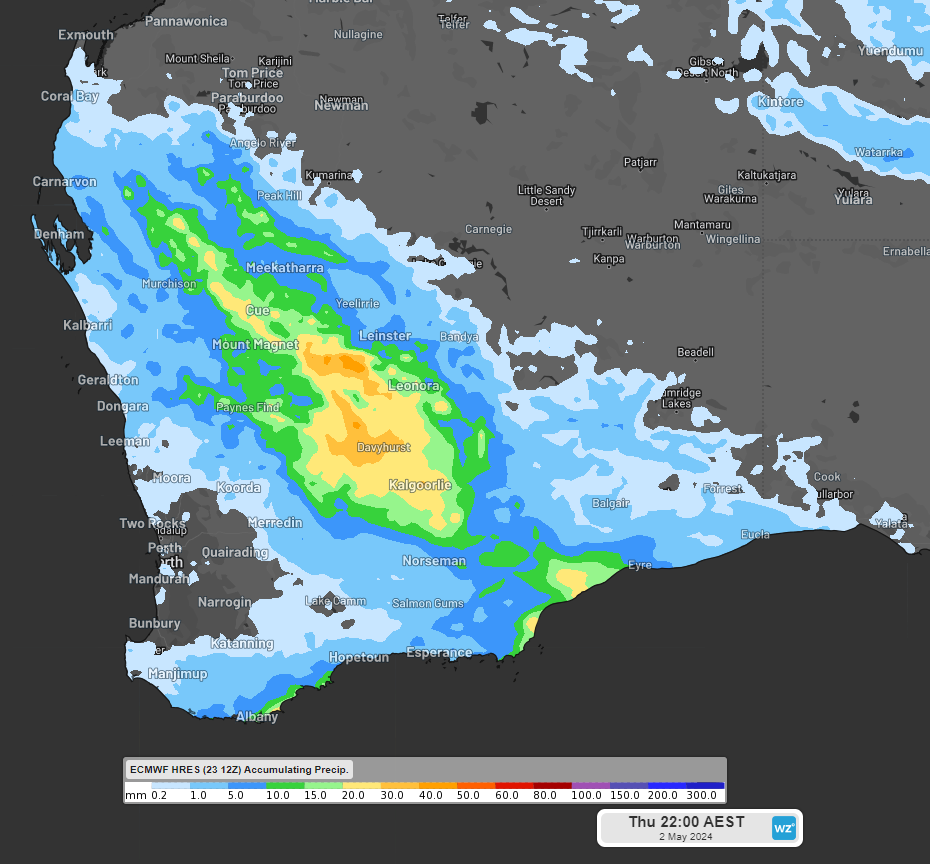
The images below shows that widespread rainfall of between 15 to 30mm is forecast in the week across western and southern WA, with isolated falls of between 40 to 60mm in the Gascoyne and Goldfields districts.
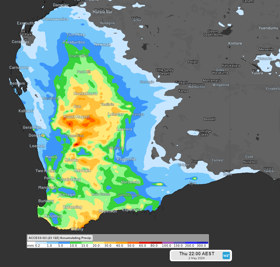

Image: Accumulated rainfall to 8pm AWST on Thursday, May 2, according to Access (top) and ECMWF (bottom)
You can see there is still some uncertainty about where and how much rainfall will fall in these areas late this week and early next week, with one model placing rain over Perth and the other predicting it will completely miss the city altogether.
The heaviest rainfall days are likely to be Friday and mid next week when the low pressure system develops.
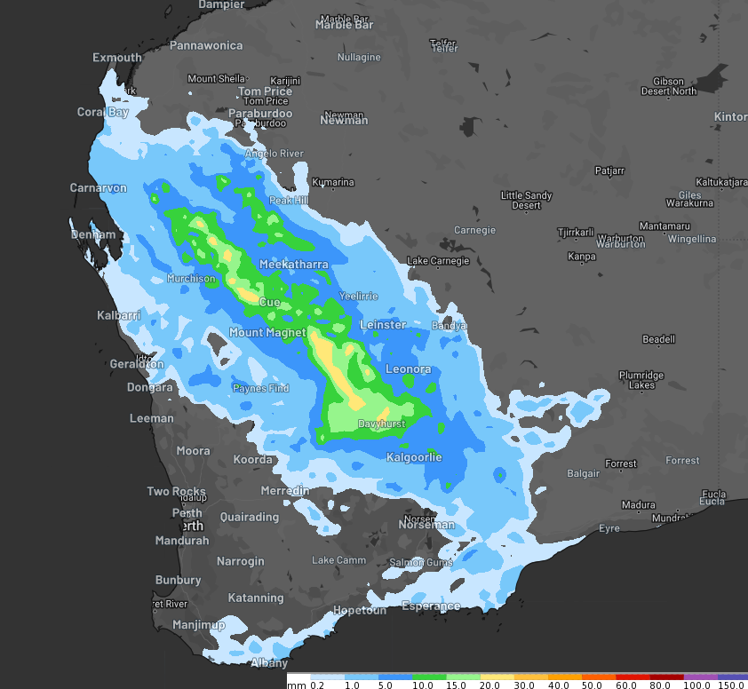
The maps below show that the rainfall forecast varies on Friday between computer models, but the highest totals should develop over the Gascoyne and Goldfields.
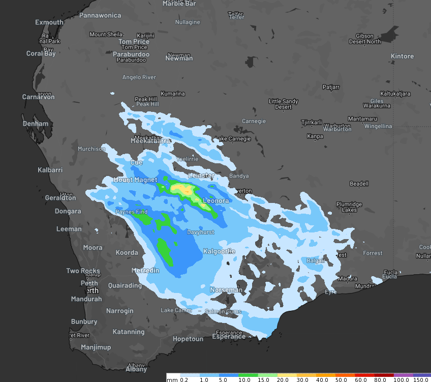
Images: Accumulated rainfall forecast for the 24 hours leading up to 11pm WST Friday, April 26, according to ECMWF (top) and Access (bottom).
Rain will ease on Saturday before developing across the far southwest on Sunday, as a cold front clips the district.
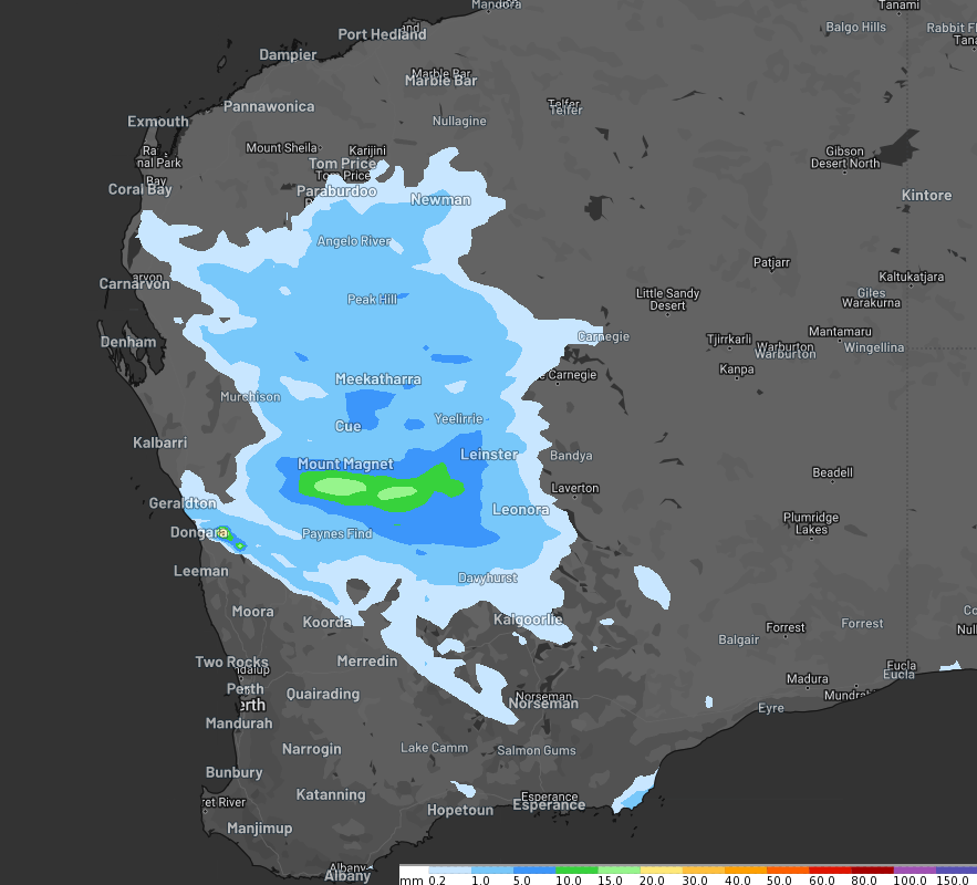
Rain will intensify early to mid-next week, with the largest totals expected on Tuesday, April 30 across western and southern WA, possibly hitting parched Perth.
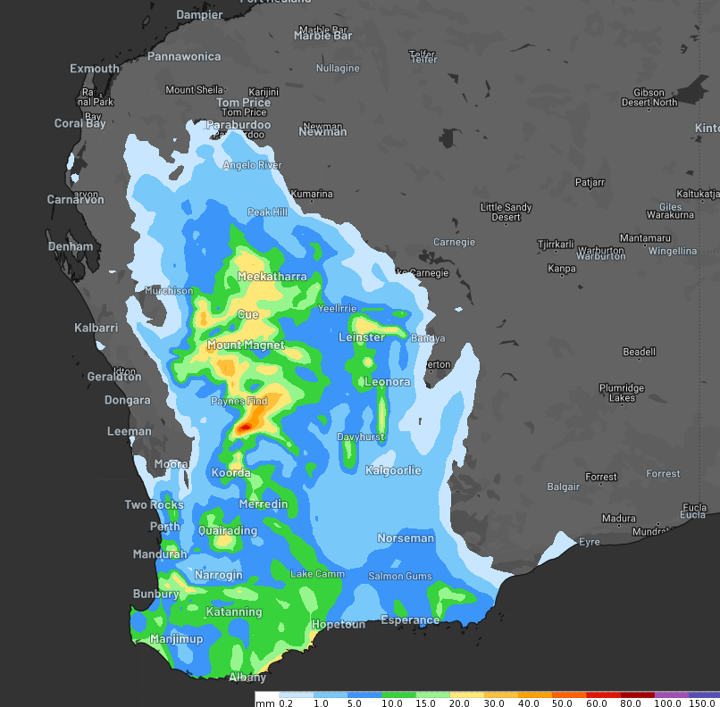
Images: Accumulated rainfall forecast for the 24 hours leading up to 11pm WST Tuesday, April 30, according to Access (bottom) and ECMWF (top).
Heavy falls of 20mm across three hourly totals is possible on Friday and again mid next week in the Gascoyne and Goldfields, possibly impacting mine operations in this region.
While this week’s rain is welcome, it’s unlikely to be drought-breaking across the bone-dry region.
The map below shows that areas of the southwest have experienced the lowest rainfall on record during the last eight months.
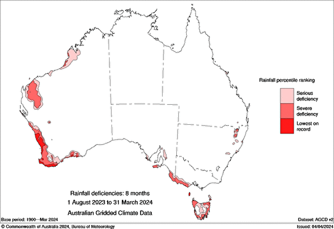
Image: rainfall deficiencies for 8 months between August 1 2023 and March 31 2024, source: Bureau of Meteorology.
The state’s southwest remains abnormally dry, with hardly any rainfall registered in the gauges in March.
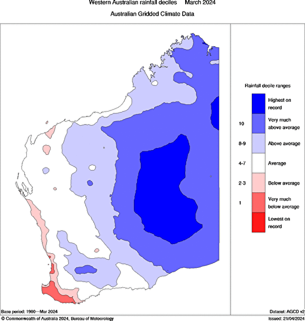
Image: WA rainfall deciles in March 2024, Source: Bureau of Meteorology
In the map above you can see March was a wet month for large areas of WA with several sites recording the highest daily rainfall on record.
Much of this rainfall fell between the 9th and 13th of March across central and southeastern parts of the state after a slow-moving trough and tropical moisture brought heavy rain and thunderstorms.
Looking ahead, there are signs of a rain-bearing cold front late next week, with the potential to hit Perth. Over the coming months, average to below-average rainfall is forecast across southern WA, but there is potential for locally above-average rain in winter.
Miningzone, by Weatherzone Business, is the only weather tracking and alerting solution purpose-built for the resources sector.
As the climate shifts into unchartered territory, weather events could affect your mine with increasing force.
Miningzone is the proven and trusted turnkey solution –deployed at over 400 mines globally – offering you tailored forecasting and alerting systems to protect your valuable staff and assets.
Weatherzone’s integrated services are intuitive and user-friendly, providing you with the specific weather and blast data needed to gain a complete environmental picture.
You will have access to our lightning and severe weather tracking and alerts, EPA-approved blast dispersion modelling, thunderstorm tracking and high precision and site-specific forecasting, along with comprehensive reporting capacity.
Precise, market-leading data is delivered via multiple platforms including Weatherguard – our easy-to-use app – and can be fully integrated into your operational control or SCADA systems.
The tailored solution to drive your decisions, for more information, please contact us at business@weatherzone.com.au.