A thick northwest cloud band is currently sweeping across the country, with the moisture-laden air originating off the far northwest shelf of Australia.
The northwest cloud band has been dragged southeast across the country this week by a deep low-pressure system.
The combination of the low-pressure system and northwest cloud band are set to bring low solar output, chilly air, high wind power and thunderstorms across the National Electricity Market (NEM).
LOW SOLAR OUTPUT
The thick cloud has reduced solar output in parts of WA, SA and the NT in the last few days as the northwest cloud band moved across the country from the west.
The cloud band has now moved into the NEM and is expected to hang around for the next three days. The band of cloud will progress to northeast NSW and southeast Queensland on Friday before moving over the Tasman Sea and moving away from Australia.
WIND POWER
While the cloud band is reducing solar capacity, the low-pressure system has well and truly increased wind power capacity across the NEM.
The low-pressure system currently to the south of SA is generating damaging winds across South Australia’s southern districts and elevated areas in VIC today.
While the winds are below damaging criteria across the rest of the NEM today, strong winds are generating high wind power across the states.
The strong winds and high wind power are expected to continue throughout tomorrow and throughout much of the NEM. Damaging winds are possible in SA tomorrow and VIC on Friday, as the low-pressure system follows the cloud band east. Winds are expected to ease by Saturday, as a high-pressure system moves into the system’s wake.
RAIN and STORMS
The northwest cloud band has already left widespread rainfall in its path in WA, SA and the NT. The band of cloud and rain has now moved into eastern Australia and is expected to bring rain and storms to the NEM during the next three days (figure 2).
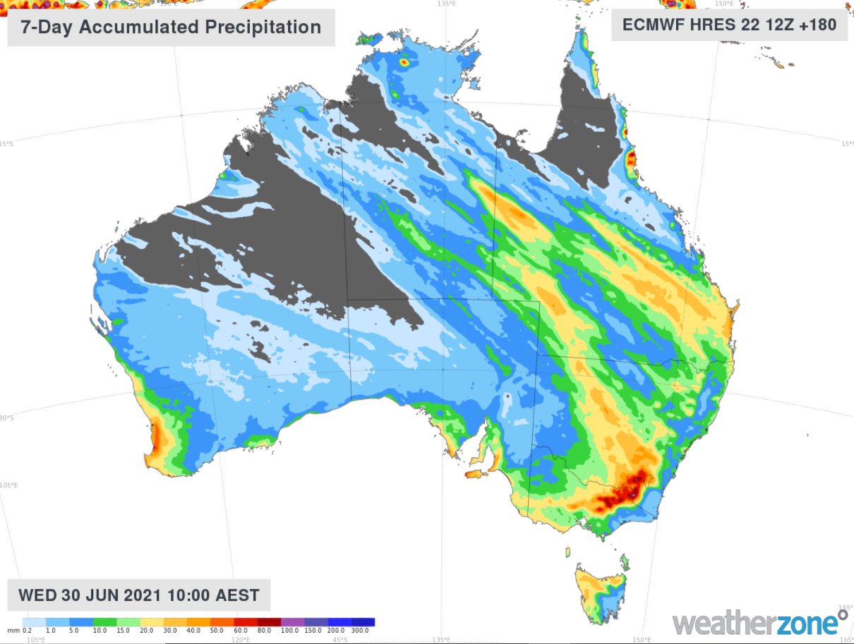
Figure 2: ECMWF weekly accumulated rainfall totals.
Large snowfall totals are predicted about the Alpine regions from today, with snowfall peaking later this week into the weekend when the snow level drops to 1200 metres.
The low-pressure system which is proceeding the rainband is expected to bring showers, thunderstorms and possible hail to SA and VIC during Thursday and Friday. There is a risk that the thunderstorms may be severe, with the possibility of damage to business infrastructure.
COOL TEMPERTURES
Cooler air is set to move through the NEM and southeastern Queensland over the weekend. Brisbane’s temperature is forecast to make it to a measly 17 degrees on Saturday, which is around five degrees below the June average. While Saturday is anticipated to be the coolest day In Brisbane, Sunday is also expected to remain two degrees below average.
The rain, wind and storms will ease from Saturday, with the low-pressure system and cloud band moving away from eastern Australia during Sunday.
For more information about Weatherzone’s 14-day energy forecasts and consultation, please contact us at business@weatherzone.com.au.


