To many Australian’s delight, renewable energy is booming across Australia. Rooftop solar is regularly installed for households and solar and wind farms are popping up everywhere.
South Australia (SA) has seen a major solar and wind farm boom in the last few years with 35% of South Australian households having solar panels installed. In fact, on Sunday, March 14, 2021, 70 per cent of the SA’s power came from rooftop solar panels alone, however, this did not exceed the 100 percent of energy demand that was met by solar panels on October 11, 2020.
This of course is a challenge for market operators, causing minimum demand events, where there is excess power in the grid, which clearly is not ideal. Solar panels were shut off during this Sunday’s event to prevent a state-wide black out. This low demand event was generated by mild temperatures and sunny conditions across South Australia, coinciding with a planned outage of circuits feeding the Heywood interconnector which links the state’s grid with Victoria.
As we integrate more solar into the energy market, minimum demand events are likely to become increasingly common throughout Australia. Accurate solar forecasts and batteries to store excess power are the answer to this problem.
While SA has been sunny with high solar influx, the eastern states are copping a drenching with cloud and rain forecast for the next week or so (Figure 1). A coastal trough off the NSW and QLD coast, coupled with onshore winds are generating the persistent rainfall.
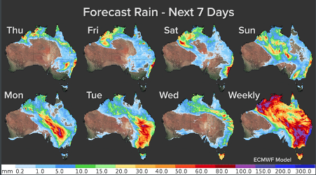
Figure 1: ECMWF model forecast rain for the next 7 days from Thursday the 18th of March
The rainfall and cloud really set in yesterday, Wednesday, March 17 for NSW and QLD, with very low solar irradiance observed (black, white and light yellows in figure 2).
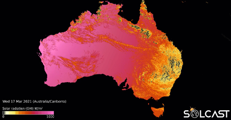
Figure 2: Solcast’s horizontal irradiance on the 17th of March 2021
While cloud bands across southern Australia are slightly more predictable to forecast, convective storms and showers across northern Australia develop very rapidly generating increased cloud cover. The rapidly developing cloud patterns can be a challenge for solar across northern Australia, which is why rapid update forecasting is a very useful tool for the industry.
Solcast produces rapid update forecasts that models cloud growth and decay by feeding high resolution (1-2km) satellite data into the forecast. The latest satellite images are ingested into the cloud-based processing system every 5-15 minutes, producing over 600 million forecasts per hour.
Why is satellite imagery so important for forecasting the weather and in turn the cloud?
Australian weather forecasts have improved out of sight, partly thanks to new, high resolution satellite data. Modern meteorology is underpinned by satellites, providing real-time situational awareness, such as the position of a tropical cyclone, and the major initial input into weather models.
Overall solar is an increasing industry in Australia and accurate real time forecasts are paramount in facilitating an economical business. For more information on Weatherzone and Solcast’s solar forecasts please contact us at business@weatherzone.com.au


