Heavy rain and severe thunderstorms will cause more flooding in parts of northern NSW and southeast QLD during the next two days.
Just weeks after being hit by record-breaking rain and major flooding, residents living along the coast and ranges in northern NSW and southern QLD are once again on high alert as thick clouds engulf the sky.
It’s an eerily similar weather pattern to on that cause catastrophic flooding at the end of February and early March:
- A pair of upper-level lows will pass over southeast QLD during the next two-to-three days
- These pools of cold air aloft are causing a surface trough to deepen near the coast of southeast QLD and northeast NSW
- This deepening low pressure trough is being fed by a steady stream of moisture-laden air from the east
- This dynamic weather pattern is going to cause heavy and persistent rain and severe thunderstorms
Rain and thunderstorms have already been heavy in southeast QLD on Sunday into Monday morning. During the 24 hours to 9am on Monday, more than 100 mm of rain was recorded in the eastern Darling Downs and the Sunshine Coast hinterland. This included 162 mm at near Jondaryn and 121 mm at Pomona.
On Monday morning, the heaviest rain contracted offshore as a low pressure trough deepened near the coasts of southeast QLD and northeast NSW. The image below shows the majority of the rain sitting just offshore at 10am AEDT on Monday.

However, a low pressure system is expected to develop within this coastal trough on Monday, most likely somewhere to the east of about Brisbane. As this low develops, easterly winds will strengthen to its south, causing rain to push over the coast and ranges.
The low will most likely start to drift south from Monday night and during Tuesday, causing heavy rain to spread from southeast QLD down along the coast and ranges of northern NSW.
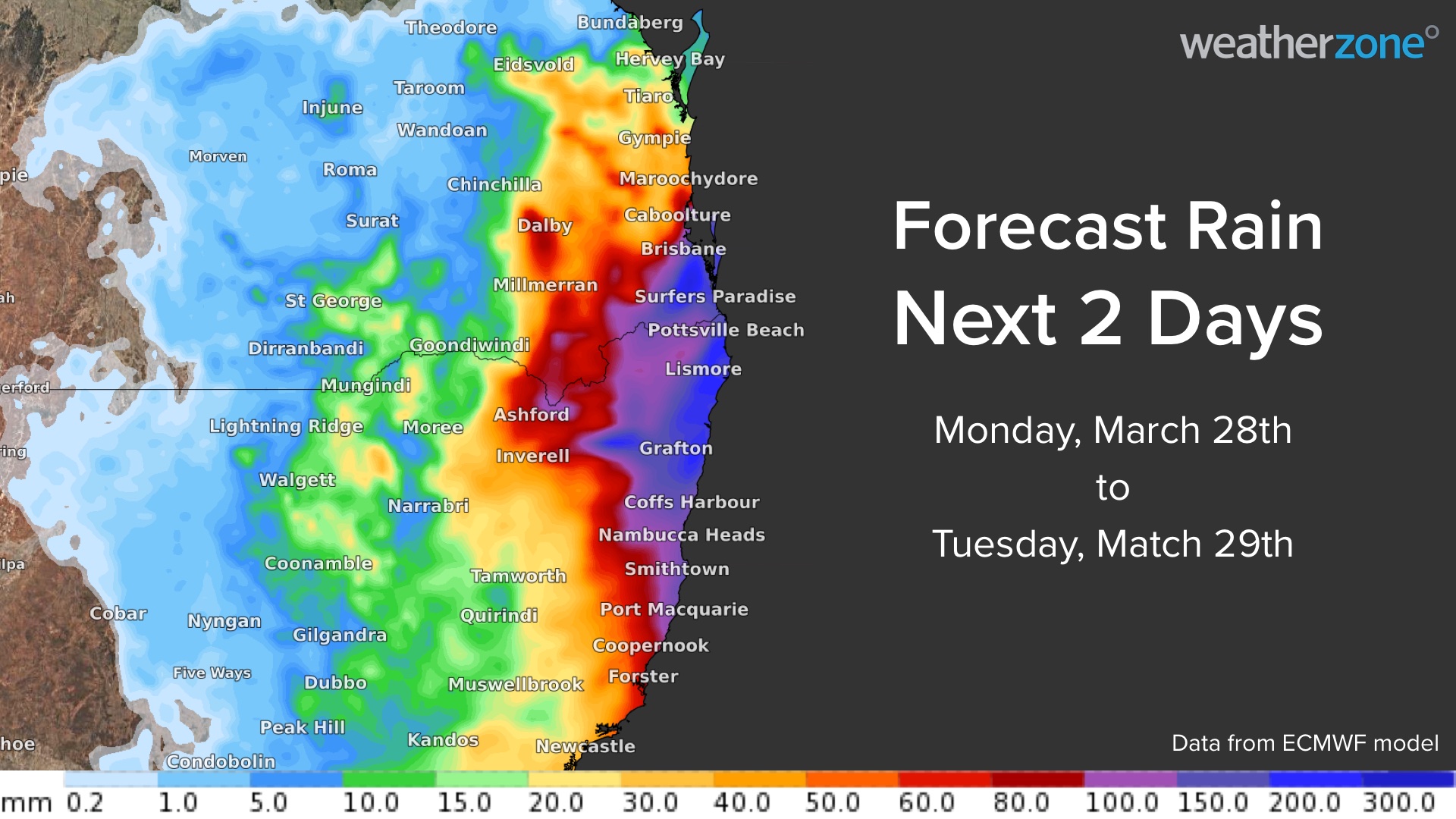
According to the latest high-resolution modelling, the heaviest rain during the next 48 hours is likely to occur between the Gold Coast in QLD and the Mid North Coast in NSW.
Two-day accumulated totals of 150-250mm are likely in some areas between the Gold Coast and the coast and ranges around Coffs Harbour, possibly higher in some pockets. There may also be short periods of very intense rainfall, particularly with thunderstorms, causing rain rates of around 100mm in three hours and 200mm in six hours.

The rain from this system most likely won’t be as heavy as the event at the end of February and early March. However, catchments are still waterlogged from that event, which will exacerbate flooding during the next 48 hours.
Rain should ease in northeast NSW and southeast QLD from Wednesday and along the Mid North Coast of NSW by Thursday as the low pressure system moves offshore.
Flood watches, flood warnings and severe weather warnings are currently in place for parts of southeast QLD and northeast NSW. Severe thunderstorm warnings may also be issued on Monday and Tuesday.
Check the latest warnings from the Bureau of Meteorology and evacuation advisories from the State Emergency Service for the most up-to-date information. For more information, please information please contact us at business@weatherzone.com.au.


