Today is World Maritime Day, which is an opportunity to highlight the importance of shipping and other maritime activities. Sea fog is a weather event that significantly impacts ports, shipping and other maritime businesses.
In fact, sea fog has been observed on several occasions off the northwest shelf of Australia this season.
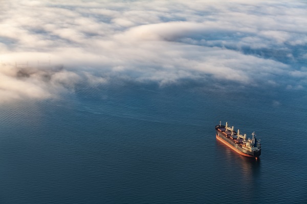
Sea fog is a rare phenomenon off the Pilbara coast, however during August it occurred three times in one week.
While the sea fog events in August were short lived, dissipating as the sun rose, the event had an impact on Port Hedland and the shipping schedules.
So why did this rare fog occur?
Sea fog is fog that forms over the ocean, when warm and humid air moves over cooler waters.
During winter, warmer than normal sea surface temperatures were being or had been observed off the northwest shelf of Australia. A negative phase of the Indian Ocean Dipole (IOD) this winter promoted warm ocean temperatures and a humid atmosphere in the region.
While the warm and humid air is conducive to sea fog, the warmer ocean temperatures and the negative IOD are not.
As it turns out, a dramatic sea surface temperature drop was observed locally off the Pilbara Coast, likely due to a transient cool ocean current or a cold-core eddy (a cut-off circular current of water).
The combination of the cool current or eddy and the warm and humid air moving over it, caused this rare sea fog event.
Can these sea fog events be linked to an active tropical cyclone season?
Firstly, tropical cyclones form over warm tropical waters, typically when the sea surface temperature is above 26.5°C. Above this threshold, each degree of warming can provide additional energy for developing tropical cyclones.
As mentioned, sea surface temperatures (SST’s) are warmer than normal to the northwest of Australia, with a weakening negative IOD.
This mix of ingredients are likely to increase cyclone activity in these waters this season compared to recent years. However, SSTs aren’t the only factor for tropical cyclone development.
In the last few years, additional wind shear (winds that change speed and direction with height) prevented many systems from building into tropical cyclones. With this in mind, the current forecast is for a near to slightly above average tropical cyclone season in Australian waters.
The humid airmass that caused the fog, was generated by the negative IOD and warm SSTs in the region, which could play a part in increasing cyclone activity this season. For information on Weatherzone’s tropical cyclone and wet season forecasts, please contact us at business@weatherzone.com.au.


