A low-pressure system will drive heavy rain and strong winds into south-eastern NSW and far eastern VIC during the next couple of days, with flooding possible in some areas.
An upper-level pool of cold air passing over NSW will allow a low-pressure system to develop at the surface, somewhere near the state’s southern or central coast on Thursday and Friday.
This surface-based low-pressure system will cause two to three days of heavy rain, blustery winds and dangerous surf along the southern half of the NSW coast and adjacent ranges from Thursday.
Rain
The location and strength of the low will determine where the heaviest rain falls. Models currently suggest that two-day accumulated totals of 100-200mm are possible along the far south coast and ranges during Thursday and Friday, with localised falls over 200mm a chance near the coast (figure 1).

Figure 1: ECMWF accumulated rainfall forecast from Wednesday to Friday at 11pm, December 1o.
Moderate to heavy rain could also extend up to the central coast and ranges if the low tracks far enough north.
Wind
Damaging wind gusts are also possible along the coastal fringe near the low from Thursday into the weekend.
Fresh to strong east to southeasterly winds will initially focus on the South Coast and adjacent ranges of NSW on Thursday into Friday morning.
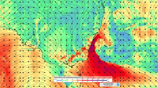
As the low pressure system become more well-defined over the western Tasman Sea from Friday, wind will turn more southerly along the NSW coast, strengthen, and extend further north (figure 2).

Figure 2: ECMWF 10m wind gust forecast at 8am Saturday, December 11.
Strong to gale force winds may develop between the South Coast and Sydney coastal districts from Friday evening into Saturday, as a powerful south to southwesterly change moves up the coast.
Swell
Wind will whip up large waves along the southern half of the NSW coast between Thursday and the weekend (figure 3).

Figure 3:Wave watch III wave height at 8am Saturday, December 11.
Wave heights are expected to reach 3-4 metres off the South Coast of NSW on Thursday and Friday. Similar wave heights will develop along the Illawarra, Sydney, and Hunter coasts from Friday into Saturday as the southerly change pushes up the coast.
Rain will ease in eastern NSW on Saturday and wind will back off gradually on Sunday as the low moves offshore. Large waves will linger into the weekend before easing early next week. For more information on our wind, wave and rainfall forecasting, please contact us at business@weatherzone.com.au.


